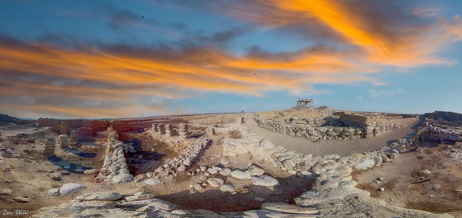
Archaeological site · The Negev
Tel Be'er Sheva National Park
The stones of a four-horned altar were found here buried inside a storehouse wall, and the well beside the town gate goes down 69 metres to the water table.
זאב שטיין / CC BY 2.5 · Wikimedia Commons
Iron Age strata
9
identified by the Tel Aviv University expedition, 1969 to 1976
Well at the gate
69 m to water
measured when it was re-excavated in the 1990s
Walled town on the summit
about 11 dunams
Stratum 2, about 300 people in 70 dwellings
World Heritage
listed 2005
with Megiddo and Hazor, as Biblical Tels
In short
- How long to give it
- about 90 minutes, against the one hour the parks authority allows for its own route
- Summer, Sunday to Thursday and Saturday
- 08:00 to 17:00
- Adult
- ₪16
תל באר שבע
Tel Be'er Sheva is a low mound about five kilometres east of the modern city of Beersheba, dug down to the street plan of an Iron Age administrative town and then left open as a national park. It is not a big site. The walled town on the summit covered roughly 11 dunams, about 1.1 hectares, and the Israel Nature and Parks Authority reckons some 300 people lived in its 70 houses. What makes it worth the detour is that almost all of that plan is visible at once, which is true of very few excavated towns anywhere.
The reason is a decision taken in the dig. Yohanan Aharoni's expedition from Tel Aviv University worked here from 1969 to 1976, and once the sequence of layers was understood the team set out to strip one layer, Stratum 2 of the late eighth century BCE, across a large part of the mound rather than sinking deeper trenches. So a visitor walks a peripheral street about two metres wide that follows the oval of the wall, past houses whose back rooms are chambers of the casemate wall itself, and into the central square where all the streets meet.
Two things at the site are worth arriving for on their own. One is a reconstructed four-horned altar at the entrance, put together from dressed stones found buried in a storehouse wall, which is one of the more concrete pieces of evidence anyone has for a Judean religious reform. The other is underground: a stepped shaft and a plastered reservoir cut into chalk, opened to the public in 2003, and a separate well beside the gate that was sunk to 69 metres before it reached water.
Strata
Nine Iron Age towns stacked on one hill
The mound rises to 307 metres above sea level and only about 20 metres above the plain around it, which in the Beersheba valley is enough to be the only hill in sight. It sits where the Hebron streambed meets the Beersheba streambed, on what the parks authority describes as the southern edge of the settled world: north of it, loess fields that take about 200 millimetres of rain a year; south and east, desert.
The first traces are Chalcolithic sherds from the fourth millennium BCE with no architecture attached. Then nothing for more than two thousand years. Settlement resumed at the end of the second millennium and ran for roughly five centuries, and the excavators separated it into nine strata. Stratum 9 was pits and huts; Stratum 7, in the tenth century BCE, was about twenty four-room houses set in an oval belt round an open yard, holding perhaps a hundred people. The first fortified town, Stratum 5, went up at the start of the ninth century behind a solid wall four metres thick, with a sloped glacis against its foot and a gate protected by a second, outer gate.
The eighth century brought a rebuild that changed everything. The solid wall came down and a casemate wall, two parallel walls partitioned into rooms, went up in its place. A new gate was built over the ruins of the old one, the outer gate was abandoned, and the water system was repaired after part of its roof fell in. The parks authority reads that scale of change as the aftermath of an earthquake, and notes that some scholars connect it to the one dated in the Book of Amos to two years before the prophet's activity.
The last biblical town, Stratum 2, burned. The destruction is placed at the end of the eighth century BCE and is generally attributed to Sennacherib's campaign of 701 BCE, the one recorded on the Assyrian king's own prism and in 2 Kings. An attempt to rebuild, Stratum 1, was given up almost at once, and the hill stayed in ruins until the Persian period.
- Chalcolithic, fourth millennium BCE: sherds, no buildings
- Strata 9 to 8, twelfth to eleventh centuries BCE: pits, huts, first stone houses
- Stratum 7, tenth century BCE: an enclosed settlement of about 20 houses
- Strata 5 to 4, ninth century BCE: an administrative town behind a solid wall
- Strata 3 to 2, eighth century BCE: rebuilt behind a casemate wall, burned about 701 BCE
- Stratum 1, early seventh century BCE: an abandoned attempt to start again
Plan
A town that was laid out before it was built
The thing to look at from the observation tower is not any single building but the shape. The town is an oval, following the contour of the hill, with one deliberate bulge eastward to bring the entrance shaft of the water system inside the defences. A street runs right round the inside of the wall, about two metres wide, and further streets cut across the middle in straight lines. Every street ends at the same place, a square just inside the main gate, which was the only open ground in the town.
That plan did not drift into existence. In the middle of the peripheral street the excavators dug down about three metres and found the line of the earlier street in the same position, which means the layout survived from Stratum 5 in the ninth century through to the end of Stratum 2 in the eighth. Houses were built into the casemate wall, so that a family's back room was a compartment of the defences. The parks authority draws the obvious inference: the people living there were responsible for holding the wall.
The public buildings sit where a planner would put them. Just inside the gate is a complex of about 600 square metres, three storerooms each split by two rows of stone pillars into three long halls, with hundreds of pottery vessels found in the debris. The middle hall of each was a passage for pack donkeys; the side halls held the goods. Nearby is a large building with an entrance corridor, two paved ceremonial halls, living quarters, a kitchen and a store, which the excavators identified with the biblical official of the town and which the park signs call the governor's palace.
The gate itself is now two gates at once, and it takes a moment to read. On the left of the passage is the left-hand side of the eighth-century gate of Strata 3 and 2; on the right, and lower, is the right-hand side of the ninth-century gate of Strata 5 and 4. Plastered benches were found in one of the gate chambers, the sort of seat the Hebrew Bible puts elders, merchants and judges on when business is done in the gate.
Altar
An altar taken to pieces and hidden in a wall
Somewhere in the eighth century BCE the people running this town dismantled its sanctuary, broke up the large stone altar that stood in it and used the dressed blocks as ordinary building material in the northern corner of the storehouse. The excavators found them there, recognised them as a set and put them back together as an altar with a horn at each of the four corners, the kind the Hebrew Bible repeatedly names. Yohanan Aharoni published the find in 1974 under the title The Horned Altar of Beer-sheba.
The interesting question is when, because the answer decides which king ordered it. Aharoni's reading, which the parks authority prints today, is that the burial belongs to the religious reform ascribed to Hezekiah of Judah at the end of the eighth century, the same programme credited with putting the temple at Tel Arad out of use. Yigael Yadin disagreed in print two years later, in a Bulletin of the American Schools of Oriental Research article titled Beer-sheba: The High Place Destroyed by King Josiah, dating the wall that held the stones considerably later and giving the credit to a different reforming king. The argument has never been fully settled in favour of one side.
There is a second oddity nearby. The Basement House, whose foundations sit about four metres down with two rooms that seem to have been cellars, struck Aharoni as too deep to be ordinary, and he suggested the depth was created by pulling down the sanctuary that had stood on the spot. That is an interpretation, not a finding, and the park's own literature presents it as his view rather than as fact.
The altar standing in the square at the entrance is a replica. The original, reassembled, is in the Israel Museum in Jerusalem, so a visitor who wants to see the actual stones needs a separate trip.
Water
One well for every day, one reservoir for a siege
A town on this hill had two separate water problems and solved them separately. Ordinary daily supply came from a well sunk just outside the gate, and it is remarkable chiefly for how far down it went. When Tsvika Tsuk re-excavated it in the first stage of Ze'ev Herzog's renewed 1993 to 1995 season, water was reached 69 metres below the surface, which is more than three times the height of the mound above the plain. The parks authority calls it one of the deepest wells in Israel. It may have been cut as early as the first Iron Age settlement on the hill.
Siege supply was a different structure altogether, built into the fortifications on the north-east side. A stone-lined shaft with a stairway set into its wall drops to a reservoir hewn out of chalk, divided into five chambers and holding roughly 700 cubic metres, fed by a winding channel that took flood water off the Hebron streambed. The two accounts the parks authority publishes do not agree on the shaft: the 2026 park brochure, whose text is by Herzog, gives 17 metres, while the authority's own website says 20. Both figures come from the operator, and it is worth knowing that before someone quotes one of them at you.
The reservoir walls are straight, and they are not decorative. They were put in as supports for the ceiling once the chambers had been quarried out, and the thick waterproofing plaster still carries the fingerprints of the people who applied it. The system went out of use at the end of the Hellenistic period, apparently when an earthquake collapsed part of it and blocked the feeder channel. It was cleared, conserved with the Israel Antiquities Authority and opened to visitors in 2003.
One practical consequence of all this: the route out of the water system is a secondary opening cut in antiquity, sealed once the work was finished and reopened by the excavators. It now serves as the exit from the mound, so on the park's own route the descent through the water system ends the visit.
Restoration
The line on the walls, and how to read it
Almost everything standing above knee height at Tel Be'er Sheva has been rebuilt, and the site is unusually straightforward about saying so. A line is marked on the structures. Below it, the walls are original and were found intact in the excavation. Above it, the stonework has been reassembled from blocks recovered in the rubble, or the wall has been raised again in mud brick, the material the Iron Age builders used on their field-stone foundations.
The restoration was carried out in 1990 by what was then the National Parks Authority, with the Negev Tourism Development Administration, under site director Eliyahu Even Haim. The scheme, including the observation tower, was designed by the architect Lawrence A. Belkin with Ze'ev Herzog as archaeological consultant. Conservation of the exposed mud-brick walls had begun much earlier, during the dig itself, and was paid for mainly by the Beersheba municipality.
That matters for what a visitor should expect. Original masonry does not survive to any height here, and anyone hoping for standing ruins will be disappointed. What it offers instead is legibility: an entire town plan you can walk in an hour, with the modern intervention labelled rather than disguised. Reconstruction of that sort is contested in conservation practice, and Tel Be'er Sheva sits at the honest end of it.
The mound was still being fortified in the twentieth century. In the First World War the Ottoman army used Beersheba as a staging area against the Suez Canal and put a gun position on top of the tel; it was taken on 31 October 1917. The parks authority's own two accounts of that day differ, the brochure crediting an ANZAC infantry unit and the website ANZAC cavalry, and the Australian War Memorial's account describes light horsemen of the 4th and 12th Regiments charging the Turkish trenches and entering the town in under an hour. At the foot of the observation tower are the remains of a diamond-shaped Roman fortress of the second or third century CE, restored in the Early Arab period.
What to look for
Things not to walk past at Tel Be'er Sheva National Park
The details that repay knowing about before you are standing in front of them.
The reconstructed four-horned altar
In the square at the entrance, rebuilt from dressed stones found buried in a storehouse wall. The original is in the Israel Museum in Jerusalem.
The well beside the gate
Sunk outside but close to the town gate, and cut to 69 metres before it reached water. Some scholars connect it with the well in the Genesis account that gives Beersheba its name.
The double gate
Two gate structures survive side by side: the eighth-century one on the left of the passage, and the lower, earlier ninth-century one on the right.
The storehouse
About 600 square metres of it, three storerooms each divided by two rows of pillars into long halls. Hundreds of pottery vessels came out of the ruins.
The observation tower
A modern tower on the summit, and the only place the whole oval town plan reads at once. It also looks out over Beersheba, Omer and Tel Sheva.
The water system
A stepped shaft down to a five-chambered plastered reservoir of about 700 cubic metres. It opened to visitors in 2003 and its far end is the exit from the mound.
The long view
Tel Be'er Sheva National Park, in order
4th millennium BCE
Chalcolithic sherds on the hill. No architecture from this period was found.
12th century BCE
Settlement resumes after a gap of more than two thousand years: pits and huts, Stratum 9.
10th century BCE
An enclosed settlement of about twenty four-room houses, Stratum 7, holding perhaps a hundred people.
Early 9th century BCE
The first fortified town, Stratum 5, behind a solid wall four metres thick, with a glacis and a double gate.
8th century BCE
The solid wall is replaced by a casemate wall and the gate rebuilt, apparently after an earthquake.
Late 8th century BCE
The sanctuary is dismantled and the altar stones buried in a storehouse wall.
c. 701 BCE
The Stratum 2 town burns, generally attributed to Sennacherib's campaign against Judah.
5th to 4th centuries BCE
A small Persian fortress on the ruins, with dozens of pits for grain and fodder.
3rd to 2nd centuries BCE
A Hellenistic temple. Its altar base can still be seen beside the Basement House.
1st century BCE to 1st century CE
A Herodian fortress with a bathhouse. Two of its plastered pools survive.
2nd to 3rd centuries CE
A diamond-shaped Roman fortress, the last building on the mound, restored in the 7th or 8th century.
31 October 1917
The Ottoman gun position on the tel falls as Allied forces take Beersheba.
1969 to 1976
Tel Aviv University excavates under Yohanan Aharoni, with Ze'ev Herzog directing the final season.
December 1986
Tel Be'er Sheva is declared a national park, covering 180 dunams.
1990
The reconstruction and the observation tower are built, to a design by the architect Lawrence A. Belkin.
1993 to 1995
Herzog reopens the dig to finish the water systems. The well is found to reach water at 69 metres.
2003
The conserved water system opens to the public.
2005
UNESCO inscribes Tel Be'er Sheva with Megiddo and Hazor as the Biblical Tels.
Practical
Visiting Tel Be'er Sheva National Park
Where
Tel Be'er Sheva National Park, off the Beersheba to Shoket Junction road, south of Omer and beside the town of Tel Sheva
Opening hours
- Summer, Sunday to Thursday and Saturday
- 08:00 to 17:00source
- Summer, Friday and holiday eves
- 08:00 to 16:00source
- Winter, Sunday to Thursday and Saturday
- 08:00 to 16:00source
- Winter, Friday and holiday eves
- 08:00 to 15:00source
- Holiday eves and the eve of Yom Kippur
- 08:00 to 13:00source
- Last entry
- one hour before the closing time abovesource
Admission
Access
The visit is a loop that climbs the mound on made paths and comes back down through the water system, by a stairway set into a stone-lined shaft that the parks authority gives as 17 metres deep in its brochure and 20 metres on its website. That descent cannot be done in a wheelchair and is hard work for anyone unsteady on stairs. The altar square, the outer gate and the well beside it are all at the foot of the mound and are the easiest part of the site. The parks authority publishes a visit coordination form for people who cannot use its standard online booking system, and says it responds within 48 hours through its call centre.
On site
- Toilets
- Drinking water taps
- Car park
- Observation tower
- Marked loop trail
- Group activity rooms by prior arrangement
Booking
The parks authority asks visitors to reserve a time slot through its online system, which it says guarantees a place on the date and time requested. Entry is also covered by the authority's Israel Pass and annual Matmon card; the Israel Pass runs for two weeks from the first entry and covers up to 70 parks and reserves, and children up to the age of five go in free.
Hours and prices are given as the operator publishes them and change without much notice, particularly around Shabbat and the festivals. Check the operator's own page before you travel for this.
Official page at en.parks.org.il →What people wish they had known
- Find the reconstruction line on the walls before anything else. Below it the stonework is original and was excavated in place; above it, it was rebuilt in 1990 from fallen blocks or raised again in mud brick. Once the eye has the line, the whole site is easier to read.
- Climb the observation tower early, not last. The oval plan, the ring street and the bulge that brings the water shaft inside the wall only make sense from above, and everything on the ground is clearer afterwards.
- The water system is the exit. Its far end is a hewn opening at the foot of the mound that the excavators reopened, so going down it ends the visit rather than interrupting it. Do not leave anything at the top of the hill.
- This is not Abraham's Well. That visitor centre is a separate site in central Beersheba. The deep well here is at the town gate, and the parks authority only reports that some scholars link it to the Genesis account, not that it is the same well.
- There is essentially no shade on the mound, which stands alone in a flat valley that takes about 200 millimetres of rain a year. Drinking water taps and toilets are on site; a hat is not.
- Check whether it is summer or winter hours before setting out, and remember the gate shuts to new arrivals an hour before closing. In winter the last admission is 15:00 on most days and 14:00 on Fridays.
The figures
Tel Be'er Sheva National Park by the numbers
Each figure carries the year it belongs to and links the source it came from.
| Measure | Figure | As of | Source |
|---|---|---|---|
| Adult admission | ₪16 | 2026 | en.parks.org.il |
| Child admission | ₪7 | 2026 | en.parks.org.il |
| Depth to water in the well at the gate | 69 m | 1995 | en.parks.org.il |
| Capacity of the rock-cut reservoir | about 700 m³ | 2026 | static-en.parks.org.il |
| Area of the national park | 180 dunams (18 hectares) | 1986 | static-en.parks.org.il |
| Area of the walled town on the summit | about 11 dunams (1.1 hectares) | 2026 | static-en.parks.org.il |
| Population of the Stratum 2 town | about 300 people in 70 dwellings | 2026 | static-en.parks.org.il |
| Height of the mound | 307 m above sea level, about 20 m above the plain | 2026 | static-en.parks.org.il |
While you are here
The rest of The Negev
Everything else in this destination with a page of its own.
Abrahams Well / CC BY-SA 3.0 · Wikimedia Commons
Museum
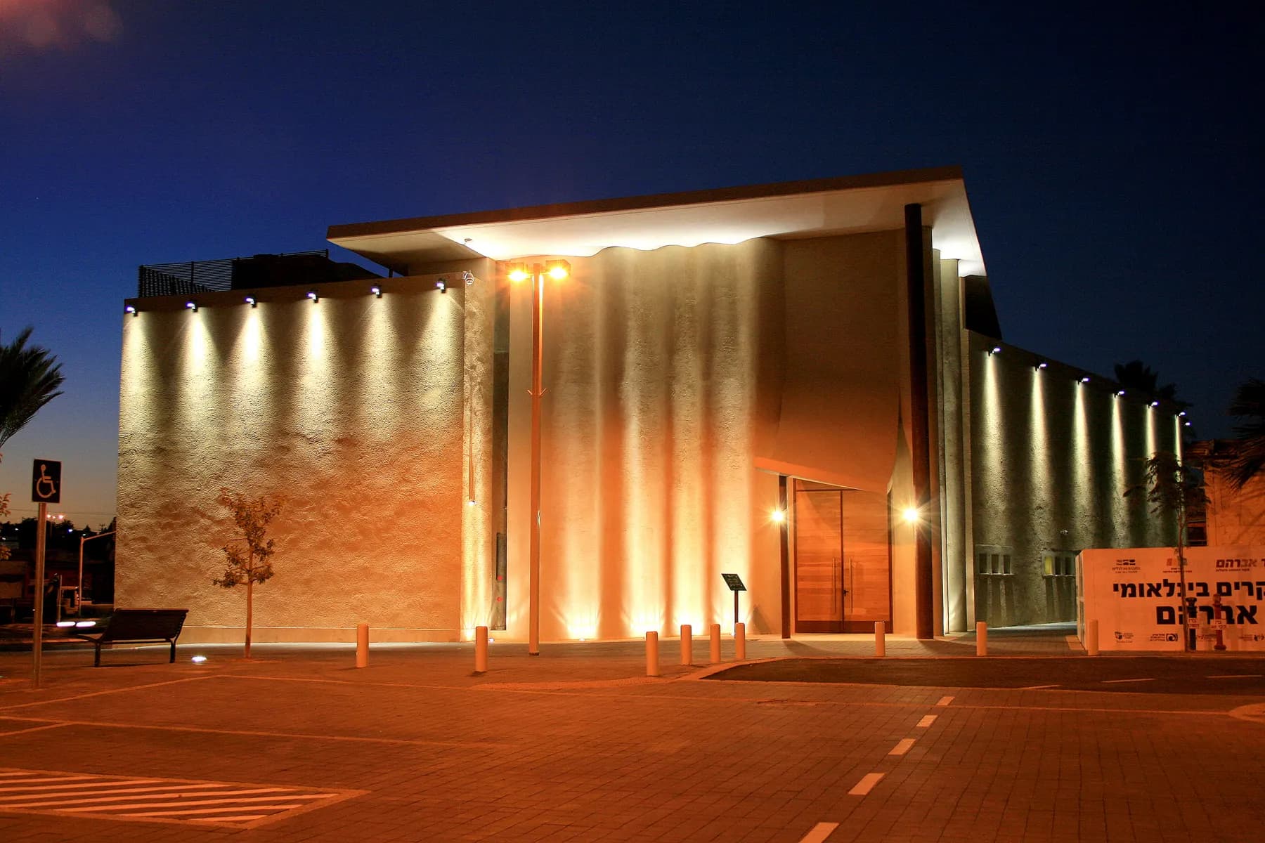
Abraham's Well International Visitor Centre
The shaft is 13.5 metres deep, and the inscribed stone Claude Conder found fifteen courses down inside it is dated 505 AH, which is the twelfth century CE.
DYKT Mohigan / CC BY 2.0 · Wikimedia Commons
Museum
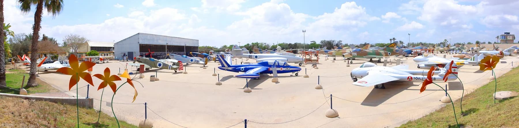
Israeli Air Force Museum, Hatzerim
The air force parks its retired and captured aircraft on an open concrete apron beside its own flight school west of Beersheba, from a Czech-built Messerschmitt copy of 1948 to the F-16 that struck the Osirak reactor in 1981.
Deror avi / CC BY-SA 3.0 · Wikimedia Commons
Archaeological site
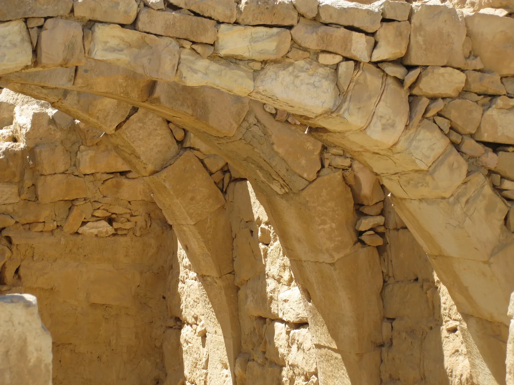
Mamshit National Park
Mamshit is the most compact of the four Negev desert cities in the UNESCO Incense Route inscription: about four hectares of Nabataean, Roman and Byzantine town inside a national park of 142.
Sources and further reading
Every link below was opened and checked when this page was written. Official statements are marked as such: they are the subject's own account, not an independent one.
- OfficialIsrael Nature and Parks Authorityen.parks.org.ilTel Beer Sheva National Park
Current opening hours and the full entrance fee table in shekels; the main points of interest, including the 69 m well, the 600 m² storehouse and the 700 m³ reservoir; the 20 m figure for the water system shaft; geographic location, the 307 m summit, hydrology and the 1986 park declaration over 180 dunams.
- OfficialIsrael Nature and Parks Authoritystatic-en.parks.org.ilTel Beer Sheva National Park: visitor brochure, 2026 edition
Text by Ze'ev Herzog, edited by Tsvika Tsuk. The table of nine Iron Age strata and the later fortresses; the station-by-station route; the 17 m shaft; the 11 dunam summit and the estimate of about 300 people in 70 dwellings; the 1969 to 1976 and 1993 to 1995 excavations; the 1990 restoration, the reconstruction line and Lawrence A. Belkin's tower; the 2005 UNESCO inscription and its four criteria.
- OfficialIsrael Nature and Parks Authorityen.parks.org.ilIsrael Pass
The pass is valid two weeks from the first entry, covers up to 70 parks and reserves, and children up to the age of five are exempt from entrance fees.
- OfficialIsrael Nature and Parks Authorityen.parks.org.ilNational Parks and Nature Reserves Visit Coordination Form
The accessible booking route for visitors who cannot use the automatic reservation system, and the authority's stated 48 hour response through its call centre.
- ReferencePenn State University Press (Eisenbrauns)eisenbrauns.orgBeer-Sheba III: The Early Iron IIA Enclosed Settlement and the Late Iron IIA-Iron IIB Cities
Ze'ev Herzog and Lily Singer-Avitz, 2016. The final excavation report of the Iron Age dig directed by Yohanan Aharoni from 1969 to 1976 for the Institute of Archaeology at Tel Aviv University, in three volumes covering stratigraphy and architecture, pottery, and artefacts.
- ReferenceThe Biblical Archaeologistdoi.orgThe Horned Altar of Beer-sheba
Yohanan Aharoni's publication of the altar, volume 37, 1974, pages 2 to 6. Cited for the excavator's own account of the find and for one side of the dating argument.
- ReferenceBulletin of the American Schools of Oriental Researchdoi.orgBeer-sheba: The High Place Destroyed by King Josiah
Yigael Yadin's reply, volume 222, April 1976, pages 5 to 17. Cited for the competing attribution of the sanctuary's destruction to a different reforming king.
- ReferenceBible Odyssey, Society of Biblical Literaturebibleodyssey.orgBeer-sheba
The HarperCollins Bible Dictionary entry: the Genesis 21 well and seven ewes that give the name, the later oath at Genesis 26, and the phrase from Dan to Beer-sheba as the standard description of the limits of Israelite settlement.
- ReferenceAustralian War Memorialawm.gov.auCapture of Beersheba, 31 October 1917
The charge by light horsemen of the 4th and 12th Regiments at the Turkish trenches, and the account of the town being entered in under an hour.
- ReferenceUNESCO World Heritage Centrewhc.unesco.orgBiblical Tels: Megiddo, Hazor, Beer Sheba
The World Heritage Centre's entry for the inscribed property, reference 1108. Every fact this page attributes to the inscription is also stated in the parks authority's own brochure and website, which are cited above.
Tel Be'er Sheva National Park: common questions
What is there to actually see at Tel Be'er Sheva?+
The excavated street plan of a small Iron Age administrative town, mostly rebuilt to about waist or chest height. That means a ring street inside a casemate wall, houses built into the wall itself, a central square, a large storehouse, a building identified as the governor's house, a double gate, a deep well outside it and an underground water system you can walk into. There is also a reconstructed four-horned altar at the entrance and a modern observation tower on the summit.
Is the four-horned altar the original one?+
No. What stands in the square at the entrance is a reconstruction. The original stones, found buried in a wall of the storehouse and reassembled, are on display at the Israel Museum in Jerusalem. The parks authority says so on both its website and in its park brochure.
Is this Abraham's well?+
The parks authority is careful here, and so is this page: it says only that some scholars suggest the well by the gate is connected with the well in Genesis 21, where Abraham and Abimelech settle a dispute with seven ewes and the oath gives Beersheba its name. It is not the same thing as the Abraham's Well visitor centre, which is a separate site in the middle of modern Beersheba. The well at the tel may have been cut as early as the first Iron Age settlement on the hill, which is far earlier than most of what is visible around it.
How long does a visit take?+
Allow about 90 minutes. The parks authority puts its own loop route at roughly an hour, which is realistic if you keep moving and skip the tower, but the water system, the gate and the storehouse each reward a stop. Groups doing the hands-on activities in the mud-brick rooms at the foot of the mound should budget longer and book ahead.
Can you go down into the water system?+
Yes, and it is the best part. A stairway set into the wall of a stone-lined shaft drops to a plastered reservoir of about 700 cubic metres cut into chalk and divided into five chambers, with the plasterers' fingerprints still in the render. It was conserved with the Israel Antiquities Authority and opened to visitors in 2003. The way out is a secondary opening hewn in antiquity and reopened by the excavators, which now doubles as the exit from the mound.
Is Tel Be'er Sheva wheelchair accessible?+
Not fully, and the water system is not accessible at all. Getting into it means a stairway down a shaft that the parks authority describes as 17 metres deep in its brochure and 20 metres on its website, and getting out means a hewn opening at the bottom of the hill. The flat ground at the entrance, with the reconstructed altar, the outer gate and the well, is the manageable part. The authority runs a visit coordination form for people who cannot use its standard booking system and says it replies within 48 hours.
Is there any shade?+
Very little. The mound is the only hill in a wide flat valley, which is exactly why it was settled and exactly why there is nothing to stand under. The site has drinking water taps and toilets. In summer the park opens at 08:00, and the first two hours are the only comfortable ones.
How does it compare with the other biblical tels?+
Tel Be'er Sheva is the smallest of the three that UNESCO inscribed in 2005, and it is the one where the town plan is clearest, because the expedition deliberately stripped a single late eighth-century layer across a wide area instead of digging deep. Megiddo and Hazor are larger and have longer Bronze Age sequences. If the question is where to understand how an Iron Age Judean town was laid out, this is the site.
Is it worth the detour from Beersheba?+
For anyone interested in how ancient towns worked, yes: it is about five kilometres east of the city, roughly ten minutes by car, and admission is modest. For anyone hoping for standing ruins it will disappoint, because almost nothing survives above knee height in its original state and the rest was rebuilt in 1990. It pairs naturally with Abraham's Well in the city centre and with the Air Force Museum at Hatzerim on the other side of Beersheba.
When is the park open?+
In summer it opens at 08:00 and closes at 17:00 Sunday to Thursday and on Saturday, and at 16:00 on Fridays and holiday eves. In winter those close an hour earlier, at 16:00 and 15:00. Holiday eves and the eve of Yom Kippur close at 13:00. Entry to the park stops one hour before the closing time in every case, and the parks authority asks visitors to reserve a slot online.