Navigation
- Business
- Technology
Latest in Technology
- Politics
Latest in Politics
Condolences to fallen soldier Aviad Walensky
2 days ago
Knesset Passes Bill to Protect People’s Jobs During Emergency Situations
2 days ago
Israel’s Foreign Minister Calls On Nations to Follow Lebanon’s Lead and Expel Iranian Ambassadors
3 days ago
Site in Jerusalem Selected for New Permanent Residence of US Embassy in Jerusalem
4 days ago
- Security
- Economy
Latest in Economy
- Crime
Latest in Crime
- Society
Latest in Society
Israel Police Arrest 114 in Crime Crackdown on Arab Society
2 days ago
Deal Reached to Ensure Ultra-Orthodox Schoolchildren can Engage in Remote Learning During Iran War In Spite of Not Having Home Internet
4 days ago
Wartime Stress Pushes Israeli Educators Toward Anxiety and Burnout, Study Finds
4 days ago
Gaza Fears Being ‘Forgotten’ as Iran War Rages
4 days ago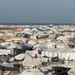
- Services
Travel & Transportation
Technology & Utilities
Religious & Cultural
Government & Public Services
Information & Directories