Nature reserve · The Negev
Ein Avdat National Park
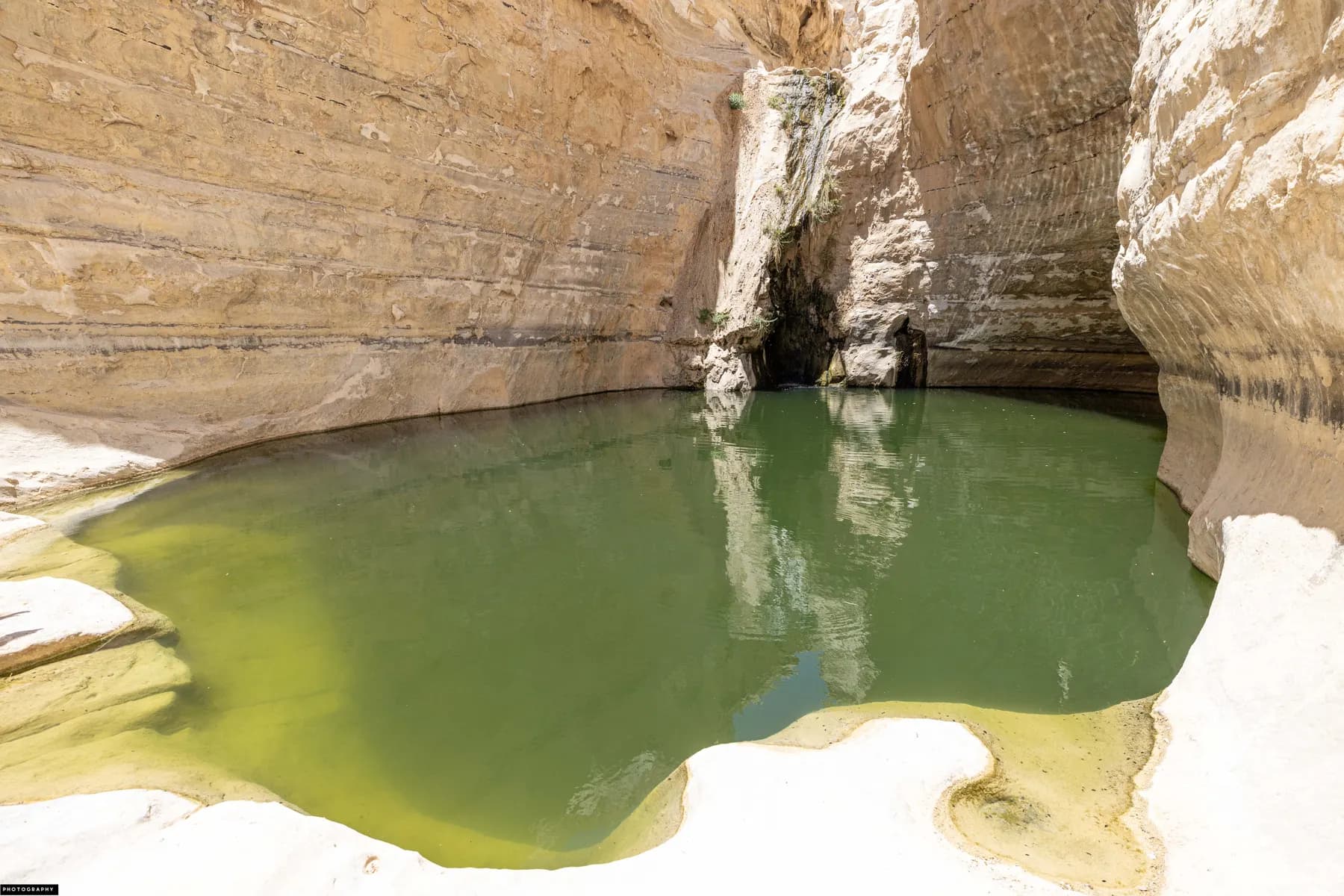
Three springs keep water running all year at the bottom of a white chalk canyon that was cleared, laid out and opened to the public in 1961 as a seventy-fifth birthday present for David Ben-Gurion.
רחל וייסלר / CC BY 2.5 · Wikimedia Commons
Waterfall
15 metres
dropping into a pool about 8 m deep, per the parks authority and the Israel Handbook
Adult ticket
₪31
child ₪16, as published by the Israel Nature and Parks Authority in 2026
Opened to the public
1961
prepared for visitors as a gift to Ben-Gurion at 75, per the parks authority
Visitors
about 315 a day
the 2019 daily mean measured at the spring, per Zukerman and colleagues, 2021
In short
- How long to give it
- about 90 minutes for the short walk to the spring and back, or about two and a half hours for the one-way climb to the upper car park
- Summer, Sunday to Thursday and Saturday
- 08:00 to 17:00
- Adult
- ₪31
עין עבדת
Ein Avdat National Park is a short, deep section of Nahal Zin where the streambed drops off the northern edge of the Avdat plateau and cuts a canyon into soft white chalk. It sits between 400 and 600 metres above sea level, below Midreshet Ben-Gurion, and it is run by the Israel Nature and Parks Authority. Three springs rise inside it, Ein Ma'arif at the top, Ein Avdat in the middle and Ein Mor beside the lower car park, and between them they keep a stream running through the bed in a place where almost nothing else does.
The set piece is roughly twenty minutes in from the lower gate. The walls close, a waterfall of about fifteen metres drops into a pool the guidebooks put at eight metres deep, and the water is cold in August. Above it the walk continues past a grove of Euphrates poplars and cave mouths that Byzantine monks cut into the cliff, then up a short vertical pitch on rock-hewn steps and bolted metal ladders. Those ladders are one way. Anyone who climbs them comes out at the upper car park, five kilometres by road from where they started.
What is easy to miss is how much of this is designed. The canyon was effectively off the map until 1960, when a member of Kibbutz Sde Boker proposed opening it as a birthday present for the prime minister next door. The road, the car parks, the stepped path and one of the pools date from that project. The chalk, the springs and the monks' caves do not.
Geology
A river that changed direction, and a plateau that fell in behind it
The parks authority's own brochure sets out the sequence, and it is the least obvious thing about the place. Before the Arava rift opened to the east, the upper tributaries of Nahal Zin drained north-west off the Avdat plateau towards Nahal Besor and the Mediterranean. The rift dropped the land east of here by hundreds of metres. Streams flowing east then eroded backwards through the soft basal clays and marls, undercut the hard Eocene limestone above them and brought it down. That collapse opened the broad bed of Nahal Zin and the HaTsinim Cliff, about twenty kilometres of it along the northern edge of the plateau, and swung the upper Besor tributaries eastward into the Zin. Geographers call it watercourse capture.
Where those captured streams met the new Zin, the height difference made rock terraces and high waterfalls, and the waterfalls cut back into deep canyons. How recently is not settled. The parks authority, reading the travertine and the scatter of prehistoric sites, puts the canyon in something like its present form about 45,000 years ago. The Israeli Mosaic account says it may have formed only 80,000 years ago. Both are estimates from indirect evidence, and they do not agree.
The walls read as stripes: pale, soft chalk that weathers back quickly, banded with hard brown and black flint that does not. Where the water it holds actually comes from is genuinely unresolved. The parks authority describes water-bearing clay strata in the canyon walls feeding the springs, and Hebrew Wikipedia calls Ein Avdat a layer spring, rain moving underground until it meets an impermeable bed and runs out sideways. BiblePlaces says flatly that scholars do not know, and that the current theory is flash-flood water seeping down through the streambed gravel. What is not in doubt is that the flow does not stop.
People were here long before the canyon looked like this. On the cliff above Ein Mor is Rosh Ein Mor, one of the best-documented Middle Palaeolithic sites in the central Negev. Rink and colleagues re-excavated it in 1996 for datable material and reported in the Journal of Archaeological Science in 2003 a uranium series burial age on ostrich eggshell of about 200,900 years, with heated flint from the same site giving much later ages of 14,000 to 48,000 years, which they read as later fires rather than as the occupation itself.
- 400 to 600 m above sea level, on the northern edge of the Avdat plateau
- HaTsinim Cliff runs about 20 km along that edge
- Canyon dated to about 45,000 years by the parks authority; another published account says 80,000
- Rosh Ein Mor ostrich eggshell dated to about 200,900 years (Rink and colleagues, 2003)
Byzantine
Four caves, a kitchen, and a prayer to Theodoros
In the sixth century, when Avdat on the ridge above had become a Christian town, monks from it moved into the canyon. The parks authority describes the caves flatly as hermitages used by monks seeking seclusion. The Israeli Mosaic account, republished by the Jewish Virtual Library, is more specific: archaeologists have investigated four of them, and inside are cut cupboards, shelves, bars for hanging clothes, benches, staircases and water systems. One is a two-room cave with a cross incised above a niche opened as a window.
Two independent accounts record the same name. A Greek inscription in the second cave from the north is a prayer to Saint Theodoros, whose name also attaches to a monastery excavated at Avdat. Uzi Paz, writing for the parks authority in 2024, reports the name Theodoros carved into a cave wall and adds that a kitchen was found in another cave, which is the detail that turns a retreat into a residence.
The monks did not only live here. A square structure stands above Ein Ma'arif near the head of the climbing path, which the brochure and Hebrew Wikipedia both read as a Byzantine lookout from which the monks descended to their caves and to small plots they cultivated by the streambed. A carved rock water channel survives near the poplar grove, and the ground under the poplars may once have been their vegetable garden.
One practical thing before setting out with the caves in mind. The parks authority's Hebrew page carries a standing notice that the access path to the monks' cave has been closed after a safety problem, while the ladder route to the upper lookout stays open. The English page does not mention the closure. The caves can be seen from the trail; reaching the doorway of one is not currently on offer.
1961
The canyon was a present, and the pool nearest the gate is not natural
Until 1961 the canyon was, in Uzi Paz's phrase for the parks authority, the end of the world and turn left. Apart from Bedouin of the Azazme with their flocks and camels, almost nobody went into it, and even Palmach scouts had not heard of it. The writer Yosef Braslavsky described it in print in 1946, in terms that suggest he could hardly believe he had got there.
In 1960 Yehoshua Cohen, one of the founders of Kibbutz Sde Boker, proposed to the Department for the Improvement of the Landscape, the body that later became the National Parks Authority, that it prepare the canyon for public visits and present it to Ben-Gurion for his seventy-fifth birthday. Until then the department had worked on antiquities sites and on recreation grounds with lawns and pools. It agreed to do something different. The layout was designed by the landscape architects Lipa Yahalom and Dan Zur, partners since 1953, who received the Israel Prize for architecture in 1998. The parks authority's own article gives their prize year as 1988, which the Azrieli Architectural Archive's record contradicts.
The consequences are visible from the first hundred metres. A surfaced road runs to the mouth of the canyon, with a car park, toilets and a picnic ground. The stepped path hewn into the rock beside the waterfall is a made thing: the Israeli Mosaic account says the steps were first cut by Israeli teenagers in 1956 and improved since by the parks authority. And the pool most visitors photograph first is artificial. Paz records that the architects judged an artificial pool would make the canyon more attractive, and built one. It silts up with wash from time to time; when it is clear, the full height of the canyon reflects in it.
The pool under the fall is the natural one, divided by a small dam. Swimming was allowed here once and is not now: the parks authority prohibits entering the water, on conservation and safety grounds, and prohibits eating inside the park.
- 1960: Yehoshua Cohen of Sde Boker proposes opening the canyon
- Designed by Lipa Yahalom and Dan Zur, Israel Prize for architecture 1998
- 1961: road, car park and stepped path open the canyon to any vehicle
- The pool near the entrance was built; the pool under the waterfall was not
- No swimming, no wading and no eating inside the park
On foot
Three walks out of two gates, and one of them cannot be reversed
The park has two entrances off Route 40, about five kilometres apart. The lower one, near Ben-Gurion's grave and Midreshet Sde Boker, is where the walking starts. The upper one is a viewpoint over the head of the canyon with no way down into it. One ticket admits the holder at both, on the day of purchase.
The parks authority's Hebrew page sets out three routes. The short one runs roughly 800 metres to the spring and back, an hour to an hour and a half. The long one continues to the poplar grove and returns the same way, two hours to two and a half. The long linear route carries on past the poplars, up the ladders and out at the upper car park, about two and a half hours, and it only works if a vehicle has been left at the top or a lift arranged. There is no walking back down: the ladders are marked ascent only, for safety.
The sequence going up is worth knowing before committing to it. From the lower car park the path passes Ein Mor, the big Atlantic pistachio and a stone dam at a trail junction, then crosses the bed to a rock terrace beside the lower pools. Back at the junction, narrow hewn steps bypass the waterfall and come out at its lip. The trail then runs upstream to the poplars, past the cave mouths, and up to the short vertical pitch of steps and ladders. At the top stands the square Byzantine structure, and beyond it the lookout over the cliffs, the upper pools and Ein Ma'arif.
Time is enforced rather than suggested. Entry closes an hour and a half before the posted closing time, and the trails are capped separately: on summer time, last entry to the long trail is 14:30 and to the short trail 15:30, an hour earlier on Fridays, and an hour earlier again on winter time. Visitors are asked to be out by 17:00, or 16:00 on Friday. The reason is not administrative tidiness. Ibex come down to the water once people have gone.
- Short trail: about 800 m to the spring and back, 1 to 1.5 hours
- Long trail: to the poplar grove and back, 2 to 2.5 hours
- Long linear trail: out at the upper car park, about 2.5 hours, ladders are ascent only
- Upper entrance alone: an accessible lookout over Ein Ma'arif, no descent
- One ticket covers both entrances on the day it is bought
Wildlife
What the ibex did when the visitors stopped coming
The park sells itself as the kingdom of the ibex and the griffon vulture, and for once the slogan is testable. Between 2019 and 2020 Yuval Zukerman, Zehava Sigal and Oded Berger-Tal set trail cameras at two Negev springs nine kilometres apart, Ein Avdat and the far more remote Ein Shaviv, and published the results in Frontiers in Ecology and Evolution in 2021. Ein Avdat took a mean of 315 visitors a day in 2019. Under the coronavirus restrictions of 2020, capped at 130 visitors an hour, that fell to a mean of 104.
The animals responded and the control site did not. In 2020 the Ein Avdat ibex came down to drink about eighty minutes earlier in the day, and the ratio of kids to females recorded at the spring more than doubled. Across the data the pattern held: the more visitors on a given day, the later the ibex arrived at the water. Nothing comparable happened at Ein Shaviv. It is the clearest published argument for why the gates here close early, and worth holding in mind when the walk feels rushed.
The birds are the other reason to look up. Griffon and Egyptian vultures nest on the wadi cliffs, and the parks authority gives the nesting season as November to August. A pair of Bonelli's eagles held territory here within living memory; Paz reports that they vanished in recent years and probably moved to Ein Akev, and that most of Israel's Bonelli's eagles were wiped out by poisoning in the 1950s, leaving the species clinging on in the desert away from farmland.
The botany is unexpected for the latitude. The grove above the waterfall is Euphrates poplar, a deep-rooted tropical tree whose main Israeli range is the Jordan valley, and it turns yellow in late autumn and winter. The streambed carries common reed, bulrush, juncus, saltbush and tamarisk. A single large Atlantic pistachio stands in the northern part of the canyon; the parks authority's brochure puts it at about 250 years old and the Israeli Mosaic account at 350. Either way it is a relict of a wetter past, putting out new leaves in summer and shedding them in winter.
What to look for
Things not to walk past at Ein Avdat National Park
The details that repay knowing about before you are standing in front of them.
The waterfall and the deep pool
About twenty minutes in from the lower gate, the walls close and a fall of roughly fifteen metres drops into a pool the guidebooks give as eight metres deep. The water stays cold through the summer, and entering it is prohibited.
The monks' caves
Cave mouths cut into the cliff above the poplars, used by monks from Avdat in the sixth century and fitted out inside with shelves, benches, staircases and water systems. The access path to the cave is closed for safety; the openings are visible from the trail.
The Euphrates poplar grove
A stand of deep-rooted tropical poplars whose main range in Israel is the Jordan valley, growing in the middle terrace of the canyon. Best in late autumn and winter, when the leaves turn yellow against white chalk.
The ladders
A short vertical pitch of hewn steps and bolted metal ladders that lifts the trail out of the canyon onto the plateau. Signed as ascent only, which is what makes the long route one way.
The Byzantine tower above Ein Ma'arif
A square structure at the top of the climb, read as a monks' lookout over the plots they cultivated by the streambed below. It is the last thing on the trail before the clifftop viewpoints.
The accessible lookout at the upper entrance
A concrete path runs from the upper car park to a viewing point over the canyon and the head of the wadi, with parking, toilets and a shaded picnic area beside it. It needs no walking in the gorge and no ladder.
The long view
Ein Avdat National Park, in order
c. 200,900 years ago
Ostrich eggshell from Rosh Ein Mor, on the cliff above Ein Mor, gives a uranium series burial age reported by Rink and colleagues in 2003, marking a minimum age for the Middle Palaeolithic occupation.
c. 45,000 years ago
On the parks authority's reading of the travertine and the prehistoric sites, the canyon reaches something like its present form. Another published account puts it at about 80,000 years.
6th century CE
Monks from Avdat occupy caves in the canyon wall, cutting cupboards, benches, staircases and water systems, and leaving a Greek prayer to Saint Theodoros in the second cave from the north.
7th century CE
After the Muslim conquest the westward roads close, and the settlement of the Avdat plateau is eventually abandoned.
1946
Yosef Braslavsky publishes a description of the gorge, one of the few written accounts of it before the state.
1952
Kibbutz Sde Boker is founded a few kilometres away, and the road south towards Eilat follows.
1956
A trail is put through the canyon, its rock steps first cut, on the Israeli Mosaic account, by Israeli teenagers.
1960
Yehoshua Cohen of Sde Boker proposes preparing the canyon for visitors as a gift to Ben-Gurion for his seventy-fifth birthday, and persuades the Department for the Improvement of the Landscape to take it on.
1961
The canyon opens to the public on a plan by Lipa Yahalom and Dan Zur, with a road to its mouth, a car park, a stepped path and a built pool near the entrance.
2020
Coronavirus restrictions cap entry at 130 visitors an hour. Ibex at the spring start drinking about eighty minutes earlier in the day, and the ratio of kids to females recorded there more than doubles.
Practical
Visiting Ein Avdat National Park
Where
Off Route 40 between Beersheba and Mitzpe Ramon. Lower entrance near Midreshet Sde Boker and Ben-Gurion's grave; upper entrance about 5 km south
What ticket you need
One ticket admits the holder at both the lower and the upper entrance on the day of purchase, so the canyon walk and the clifftop lookout are a single admission rather than two. The parks authority also lists Ein Avdat as part of the trail network of the Metzok HaTsinim nature reserve.
Opening hours
- Summer, Sunday to Thursday and Saturday
- 08:00 to 17:00source
- Summer, Friday and holiday eves
- 08:00 to 16:00source
- Winter, Sunday to Thursday and Saturday
- 08:00 to 16:00source
- Winter, Friday and holiday eves
- 08:00 to 15:00source
- Rosh Hashanah eve, Passover eve and Yom Kippur eve
- 08:00 to 13:00source
- Entry closes
- one and a half hours before the posted closing timesource
- Last entry to the long trail (summer time)
- 14:30, and 13:30 on Fridayssource
- Last entry to the short trail (summer time)
- 15:30, and 14:30 on Fridayssource
- Winter time
- all last-entry times exactly one hour earliersource
- Leave the site by
- 17:00, and 16:00 on Fridaysource
Admission
Access
The canyon walk is not wheelchair accessible and cannot be made so: it crosses a rough streambed, climbs narrow steps hewn into rock and ends on bolted metal ladders marked ascent only. The parks authority has instead made both entrance areas accessible. At the lower entrance (Ein Mor) that means parking, a toilet, a shaded picnic corner, signage and a viewpoint over the mouth of the canyon. At the upper entrance (Ein Ma'arif) it means parking, a visitor service centre, a toilet, a shaded picnic area and a concrete path from the entrance to an accessible lookout over the canyon. Dogs are not admitted anywhere in the park, and the parks authority states that this includes service animals.
On site
- Toilets at both car parks
- Shaded picnic areas at both entrances
- Visitor service centre with drinks, snacks, hats and sunscreen
- Accessible lookout at the upper entrance
- Ramat Negev Birding Centre at the lower entrance
- Parking at both entrances
Booking
The parks authority asks visitors to reserve a time through its online booking system, and says that if the site is full on arrival a reservation confirmation must be shown at the gate to get in. Telephone 08-6554418 for the site, or *3639 for the authority's information line.
Hours and prices are given as the operator publishes them and change without much notice, particularly around Shabbat and the festivals. Check the operator's own page before you travel for this.
Official page at en.parks.org.il →What people wish they had known
- Decide which trail before buying the ticket, because the long linear route needs a second vehicle at the upper car park and there is no way back down the ladders. Two groups with two cars can swap keys at the top.
- Start at the lower entrance, not the upper one. The upper car park is a viewpoint with no descent into the gorge, and people who drive there first often think they have seen the park.
- Watch the trail cut-off rather than the closing time. Entry stops an hour and a half before closing, and the long trail closes an hour before the short one, so arriving at three in the afternoon in summer means the short walk only.
- Carry water and drink it. The spring water is not potable, the park bans fires and food inside it, and there is shade only in the poplar grove.
- Do not plan to swim. Entering the water is prohibited on conservation and safety grounds, and the pool below the fall stays cold enough to be a shock even in August.
- Do not bring the dog. Dogs are barred from this park entirely, and the parks authority states that the ban extends to service animals, which is not the rule at every site it runs.
The figures
Ein Avdat National Park by the numbers
Each figure carries the year it belongs to and links the source it came from.
| Measure | Figure | As of | Source |
|---|---|---|---|
| Ein Avdat waterfall | about 15 m | 2026 | static-en.parks.org.il |
| Pool below the waterfall | about 8 m deep | 2026 | en.wikipedia.org |
| Upper waterfall above Wadi Zin | about 60 m | 2026 | static-en.parks.org.il |
| Elevation of the park | 400 to 600 m above sea level | 2026 | static-en.parks.org.il |
| HaTsinim Cliff | about 20 km long | 2026 | static-en.parks.org.il |
| Short trail | about 800 m, 1 to 1.5 hours | 2026 | parks.org.il |
| Daily visitors at the spring | a mean of 315 in 2019, and 104 in 2020 | 2021 | frontiersin.org |
| Rosh Ein Mor ostrich eggshell | about 200,900 years | 2003 | cris.haifa.ac.il |
While you are here
The rest of The Negev
Everything else in this destination with a page of its own.
Museum
Ben-Gurion's Desert Home and Tomb
David and Paula Ben-Gurion moved into a Swedish prefabricated hut at Kibbutz Sde Boker on 14 December 1953, and his will asked that it be left exactly as he died in it twenty years later.
ישראל פרקר / CC BY 2.5 · Wikimedia Commons
Archaeological site
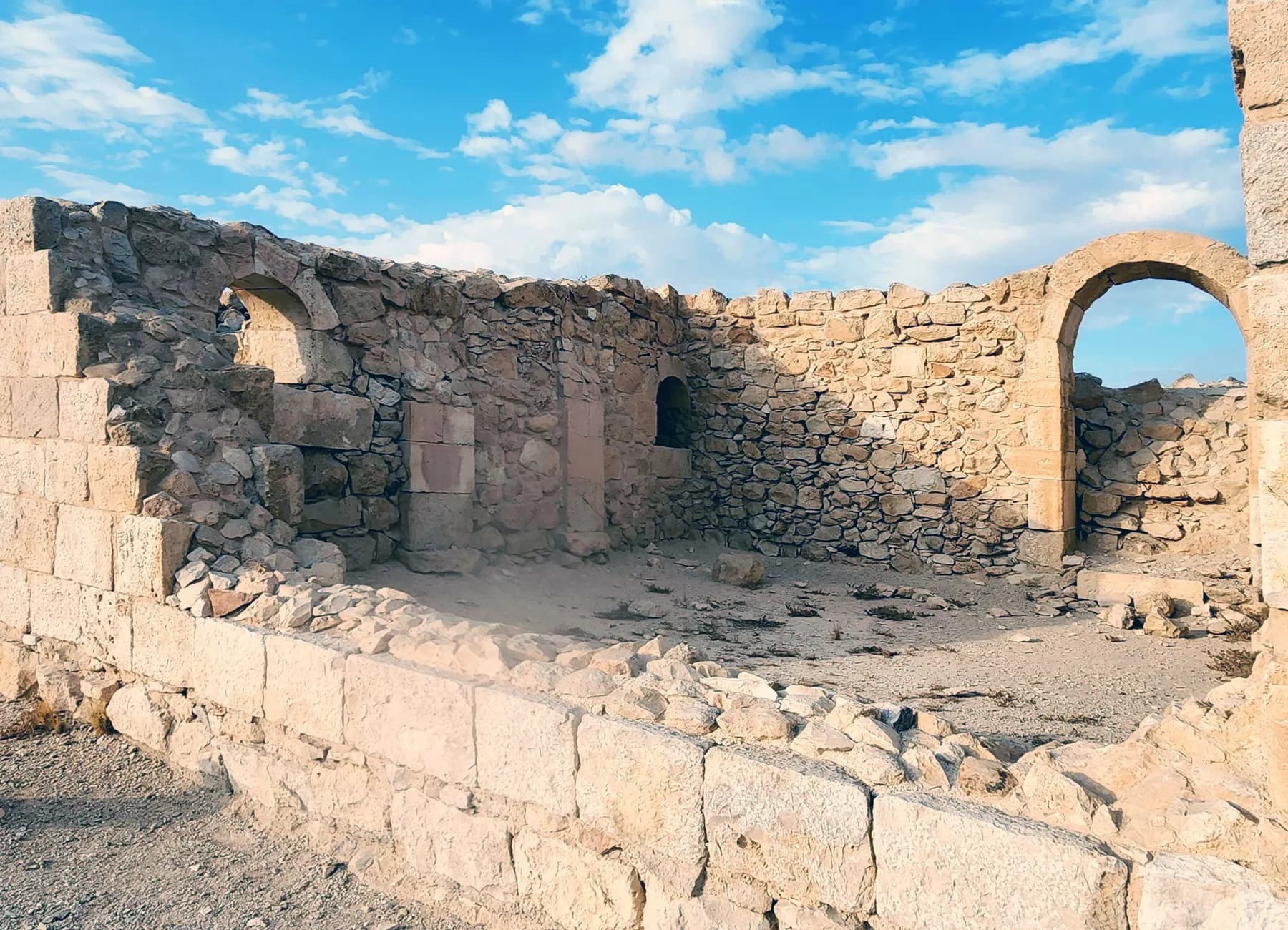
Avdat National Park
Avdat was station number 62 on the Incense Route, and the caravan road that brought frankincense from Arabia towards the port of Gaza can still be picked out climbing to it from the southeast.
Orhat / CC BY-SA 4.0 · Wikimedia Commons
Nature reserve
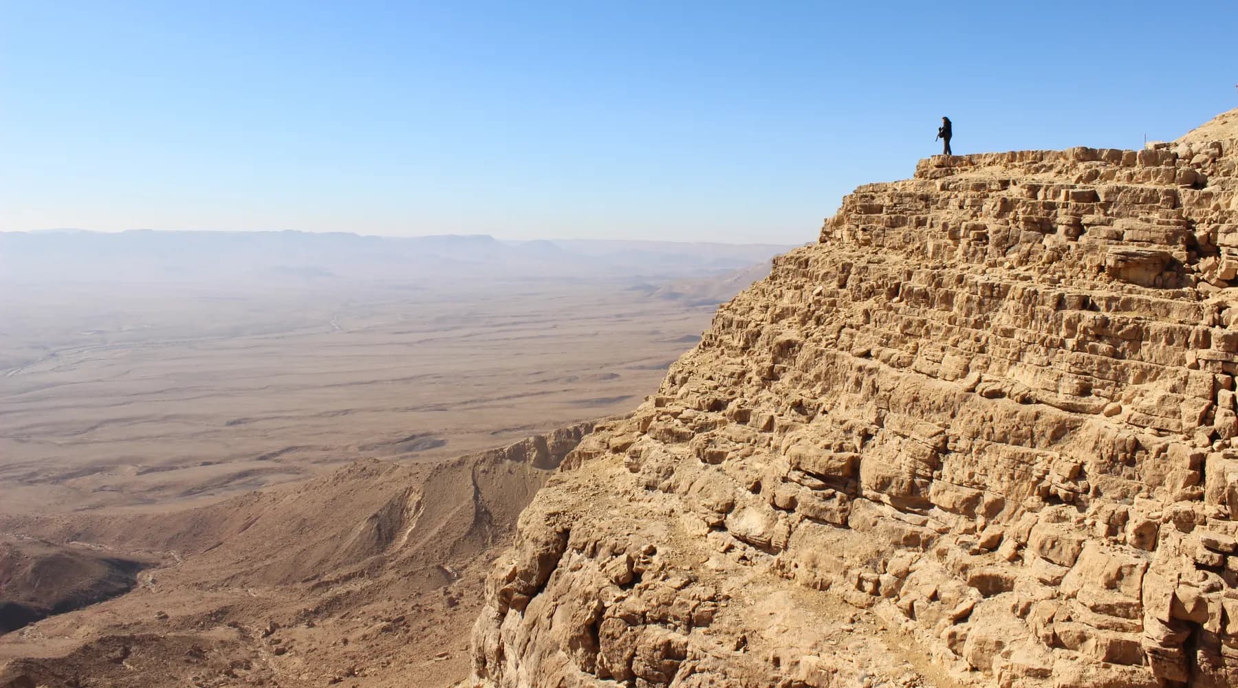
Makhtesh Ramon (Ramon Crater)
The floor of the makhtesh was quarried for clay and quartz before it was protected, and the parks authority's scenic road across the eastern half runs over ground it had to rehabilitate.
Sources and further reading
Every link below was opened and checked when this page was written. Official statements are marked as such: they are the subject's own account, not an independent one.
- OfficialIsrael Nature and Parks Authorityen.parks.org.ilEn Avdat National Park
Opening hours, trail entry deadlines and the published entrance fees
- OfficialIsrael Nature and Parks Authorityparks.org.ilגן לאומי עין עבדת
The three trails and their timings, the closure of the monks' cave path, accessibility at both entrances and the fuller price list
- OfficialIsrael Nature and Parks Authoritystatic-en.parks.org.ilEn Avdat National Park visitor brochure (PDF)
Geology and watercourse capture, the springs, the trail description, the safety rules and the flora and fauna lists
- OfficialIsrael Nature and Parks Authority (Uzi Paz, 2024)parks.org.ilגן לאומי עין עבדת: מתנה לבן-גוריון ליום הולדתו ה-75
The 1960 proposal by Yehoshua Cohen, the 1961 opening, the designers, the artificial pool and the Theodoros inscription
- ReferenceFrontiers in Ecology and Evolution (Zukerman, Sigal and Berger-Tal, 2021)frontiersin.orgCOVID-19 Restrictions in a Nature Reserve Reveal the Costs of Human Presence for the Threatened Nubian Ibex
Daily visitor means for 2019 and 2020 and the measured change in ibex drinking behaviour
- ReferenceJournal of Archaeological Science (Rink and colleagues, 2003)cris.haifa.ac.ilAge of the Middle Palaeolithic Site of Rosh Ein Mor, Central Negev, Israel
The uranium series burial age on ostrich eggshell from the site above Ein Mor
- ReferenceJewish Virtual Library, from The Israeli Mosaicjewishvirtuallibrary.orgNational Parks in Israel: Ein Avdat National Park
The four investigated monks' caves, the Greek prayer to Saint Theodoros, the 1956 steps and a competing age for the canyon
- ReferenceWikipediaen.wikipedia.orgEin Avdat
Nahal Zin's length and course, the depth of the pool below the waterfall and the wildlife list
- ReferenceHebrew Wikipediahe.wikipedia.orgעין עבדת
The square Byzantine tower above Ein Ma'arif, the layer springs and the height of the upper fall
- ReferenceAzrieli Architectural Archiveazrieliarchitecturalarchive.comLipa Yahalom and Dan Zur Collection
The partnership from 1953 and the Israel Prize for architecture in 1998
- ReferenceBiblePlacesbibleplaces.comNahal Zin, Ein Avdat
Nahal Zin's length and catchment, the 15 m waterfall, the unresolved source of the springs and a second record of the Greek prayer to Theodoros
Ein Avdat National Park: common questions
How long does Ein Avdat take?+
The short walk to the spring and back is about 800 metres and takes an hour to an hour and a half on the parks authority's timing. Continuing to the poplar grove and returning the same way takes two to two and a half hours. The one-way route out through the ladders to the upper car park takes about two and a half hours and needs a vehicle waiting at the top.
Is the canyon walk a loop?+
No, and this is the thing most first-time visitors get wrong. The full route is linear because the ladders near the top are signed for ascent only, so anyone climbing them exits at the upper car park about five kilometres by road from where they parked. The short and long trails are out-and-back walks from the lower entrance, and those can be reversed.
How much does it cost?+
The Israel Nature and Parks Authority publishes ₪31 for an adult and ₪16 for a child, with ₪26 for a student, ₪16 for an Israeli senior citizen, and ₪26 and ₪14 for adults and children in groups of more than thirty. The Hebrew price list adds ₪23 for a reservist, ₪16 for a soldier and ₪8 for a pupil. One ticket covers both entrances on the day it is bought.
Can you swim in the pools?+
No. Entering the water is prohibited, for conservation of the flora and fauna and on safety grounds, and the brochure also warns against slipping near the pools. Swimming was permitted here in the past, which is why older accounts describe it, but the ban is current and posted.
Is it wheelchair accessible?+
The canyon itself is not, and cannot be: the trail crosses a rough streambed, climbs narrow steps cut into rock and finishes on metal ladders. The parks authority has made the two entrance areas accessible instead, including a concrete path from the upper car park to a lookout over the canyon, with accessible parking, toilets and shaded picnic areas at both gates.
Can you get to the monks' caves?+
Not at the moment. The parks authority's Hebrew page states that the access path to the monks' cave is closed after a safety problem, while the ladder route up to the upper lookout stays open. The cave mouths are visible from the trail below them. The English version of the same page does not mention the closure, so check the Hebrew page or telephone before making a special trip for it.
Is there shade, and how bad is it in summer?+
There is shade in the poplar grove and at the picnic areas by both car parks, and not much anywhere else. Sun on white chalk is punishing, so the practical answer in July and August is to walk early, since the gates open at 08:00 and the long trail closes to new entries at 14:30 on summer time. The parks authority asks visitors to wear a hat and carry water, and notes that the spring water is not drinkable.
Is it worth it if there has been no rain?+
Yes, because the springs run all year regardless of the season. Where their water comes from is a live question (the parks authority points to water-bearing strata in the canyon walls, while other accounts say the source is not established and may be flood water stored in the streambed gravel) but the stream and the waterfall do not stop. What rain changes is the spectacle at the top: after a storm in the high Negev, floodwater pours over the dry fall at the head of the canyon, which can be watched from the upper entrance.
How does it compare with Ein Gedi?+
Ein Avdat is much smaller and much more contained: one canyon, one waterfall, and a walk measured in hundreds of metres rather than kilometres. It is also a designed visit, laid out in 1961, with a built pool near the gate and a fixed one-way exit. Ein Gedi offers a longer day and more trail; Ein Avdat offers a tighter, stranger piece of landscape and pairs naturally with Avdat and Ben-Gurion's hut on the same drive.
Do you need to book?+
The parks authority asks visitors to reserve a time through its online system and says a confirmation may have to be shown at the gate if the site is full on arrival. It is not always enforced on a quiet weekday, but the park caps numbers and the trails have their own entry deadlines, so a reservation removes the risk of driving an hour and being turned back.