Neighbourhood · Caesarea
Jisr az-Zarqa
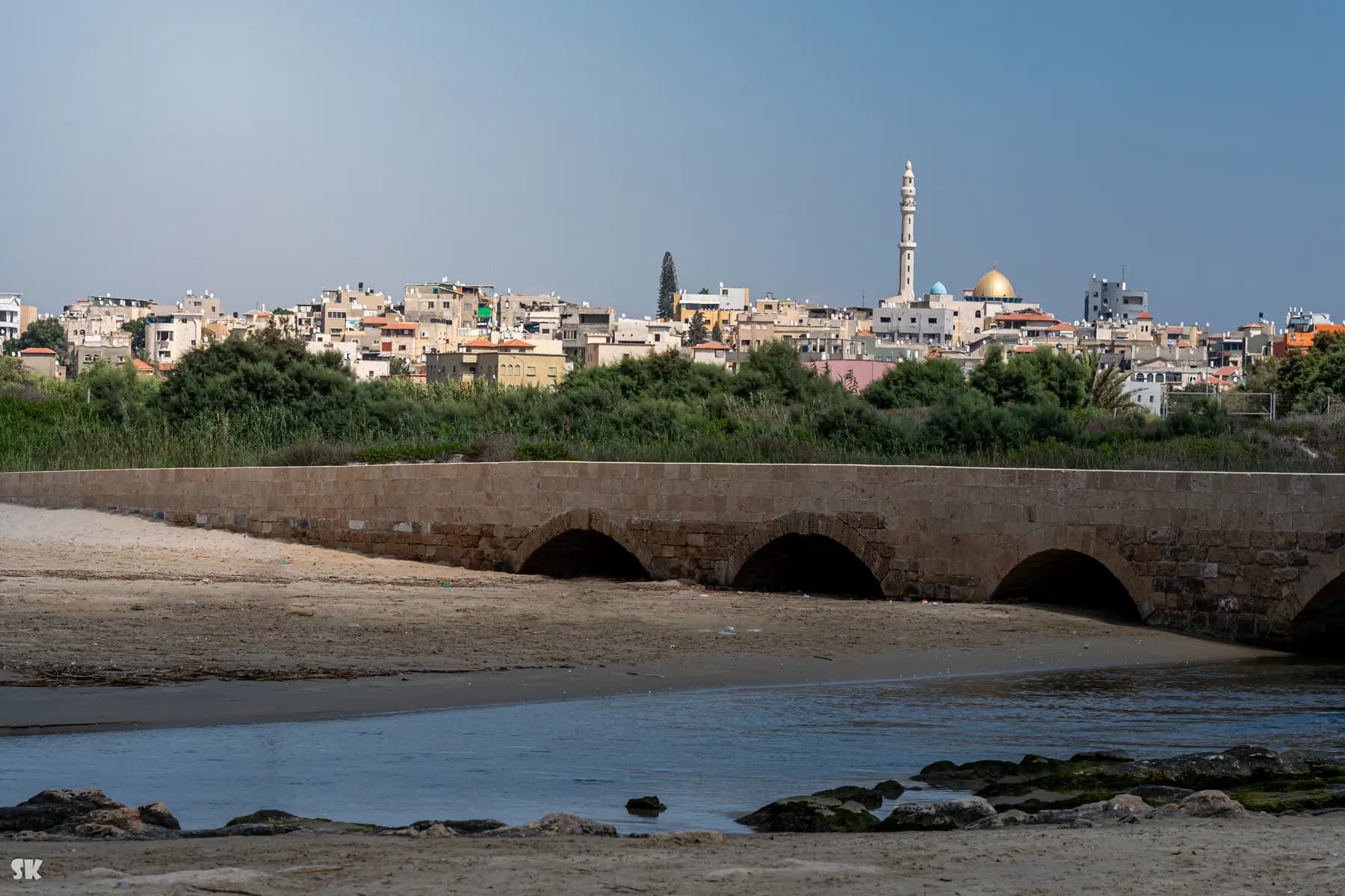
The town on the ridge north of Caesarea was laid out in 1926 for marsh dwellers displaced when the Kabara swamp was drained, and its local council calls the fishermen's village below it the only one still working on the Israeli coast.
שי קנדלר / CC0 · Wikimedia Commons
Population
15,709
end of 2023, Central Bureau of Statistics
Jurisdiction
1.65 km²
total municipal area in the 2021 land-use table
Density
9,522 per km²
and 18,452 per km² of built residential land
Fishing families
about 30
households owning boats, per the local council
In short
- How long to give it
- about 2 hours for the harbour, the bridge and the beach, or half a day with a meal and a guided walk
- The town
- Open at all times. It is a residential town, not a ticketed site, and it has no gate or visitor centre.
- The town
- Free. There is no admission charge and no ticket office.
ג'סר א-זרקא · جسر الزرقاء
Jisr az-Zarqa is a town of about 15,700 people on a low sandstone ridge directly north of Caesarea, and its own local council describes it as the only Arab town on Israel's Mediterranean coastal plain. The name is Arabic for the bridge over the blue, after the crossing of Nahal Taninim, the stream the town sits beside. Below the houses, at the mouth of that stream, is a working fishing harbour: small open boats, nets on the sand, and a beach the council keeps free to enter.
It is not an antiquity and it is not a resort, which is why it reads so differently from everything else in this destination. Caesarea National Park is a ticketed site with a car park and a film about Herod. Jisr az-Zarqa is a residential town with no visitor centre, no gate and no opening hours, where the things worth seeing are a harbour, a bridge, a mosque, a beach and whatever a local guide is prepared to show.
The town is also the most crowded piece of ground in this part of the country. The Central Bureau of Statistics gives its whole jurisdiction as 1,650 dunams, holding 9,522 people per square kilometre, and puts it in the second of ten socio-economic clusters, ranked eighteenth from the bottom among 255 local authorities. Highway 2 runs along its eastern edge, the sea closes the west, the Taninim reserve the north, and Caesarea the south. Where a town normally has suburbs, this one has boundaries.
Orientation
A kilometre and a half of town between a motorway and the sea
The shape of the place explains most of what a visitor notices. The council's own description puts the town on a kurkar ridge 25 metres above the sea, next to the lower section of the Nahal Taninim nature reserve. The Central Bureau of Statistics gives the municipal area as 1,650 dunams in its 2021 land-use table, of which 830 dunams is housing, and records a density of 9,522 people per square kilometre across the whole jurisdiction and 18,452 across the built residential part alone. That is a large town packed into the footprint of a small one.
Access is awkward by design rather than by accident. Highway 2, the main coastal motorway, forms the eastern boundary, and the Hebrew account of the town describes the two ways in: a bridge over the highway at the northern end and an underpass beneath it in the middle. The English account puts it more bluntly, noting that the coastal highway was built without providing access to the village at all. Ahmad Juha, who set up a guesthouse here, told the Times of Israel in 2015 that the village is like an island.
The population is young and entirely Muslim. The statistics bureau records the religious composition as 100 percent Muslim and 45 percent of residents as under twenty, with 2.4 percent aged 65 or over. Thirteen people sit on the local council, which the same bureau dates to 1963.
The practical consequence is simple. Streets are narrow, unsignposted and often without pavements, and there is nowhere central to leave a car. The beach car park at the western edge is the place to start, and everything else is a walk from it.
- Jurisdiction: 1,650 dunams, of which 830 dunams is housing (CBS, 2021 land use)
- Density: 9,522 people per km², or 18,452 per km² of built residential land
- Age: about 45 percent under 20, and 2.4 percent aged 65 or over
- Local council status since 1963, with 13 council members
Origins
From the Kabara marshes to a village built on quarried rock
The people here are Ghawarina, marsh Arabs, and the English account of the town calls it the only surviving Palestinian village inhabited primarily by them. They were not one clan but several: the Jurban from the Jordan Valley, the 'Ammash from Kafr Qaddum, the al-Najjar from Al Arish in Egypt, the Shihab from the Hauran, and the Tawat-ha and Umbashi, freed people of Sudanese origin. The Palestine Exploration Fund's survey of 1882 recorded small encampments of Arabs living permanently in the marshes of the river Zerka, and a population list of 1887 gave Guwarnet ez Zerka about 335 inhabitants, all Muslim.
The marshes themselves were the second largest wetland in the country after the Huleh, roughly six square kilometres of standing water on the Carmel coastal plain, and a reservoir of anopheles mosquitoes and malaria. In 1922 the Jewish Colonization Association bought the ground with Rothschild money and began draining it; from 1924 the work passed to PICA. The first plan, by a French engineer, Leon Krone, was reworked by a Russian agricultural engineer, Dov Koblanov, after he found that underground seepage was feeding the swamp.
Draining the marsh took away the marsh dwellers' living. The Hebrew account records that PICA bought replacement land and that the Ghawarina were moved onto the kurkar ridge in 1926, which is why it calls Jisr az-Zarqa the only Arab locality in the country founded by Zionist institutions. The dates do not line up neatly: the local council dates its fishermen's village to 1922, four years before the resettlement. Mandate censuses count 348 Muslims in 1922, 572 in 1931 and 620 by 1945, on 3,428 dunams of land.
The town survived 1948 for an unusual reason: Jewish residents of Zikhron Ya'akov and Binyamina, whose farms depended on labour from Jisr, intervened to prevent its population being dispersed. Every other Arab community on this stretch of coast, including the Bosniak village inside the Caesarea ruins, went in that war. This one did not.
Fishing
The boats at the stream mouth, and how much fishing is left
The fishermen's village is the reason most visitors come, and the claim made for it is a strong one. The local council's English page dates the village to 1922, calls it the only remaining fishing village along the coast of Israel that is still active, and says it supports about thirty families who own fishing boats. There is no gate and no ticket: the boats sit on the sand at the mouth of Nahal Taninim, and the working day is dawn and dusk rather than the middle of the afternoon.
How much of the town still lives from the sea is a different question, and the sources do not agree. The council presents the fishery as active. The Hebrew account of the town says there is a small fishing harbour with boats near the stream mouth but that few residents actually make a living from fishing, and lists teaching, domestic work and regional industry as the real employers. The English account notes pollution and overfishing in the coastal waters as the pressures on what remains. A visitor should expect a small working beachfront rather than an industry.
The wage figures behind that picture come from the statistics bureau rather than from anybody's argument. Of salaried residents in 2022, 39.2 percent earned below the minimum wage and 68.9 percent below the median wage, on a mean monthly salary of 7,642 shekels.
None of that is on display at the harbour, which is a working slipway with nets, crates and a view south to Caesarea. It is worth walking down early: the fish served in the town's restaurants comes off these boats.
The bridge
The crossing the town is named after, and the tunnel nobody can enter
The bridge in the name is a real structure over Nahal Taninim, known locally as Wadi az-Zarqa, the blue. The council says it was built at the end of the Ottoman period in honour of the visit of Kaiser Wilhelm II to Palestine in 1898, and the Hebrew account adds that it was restored in 2020. The Palestine Exploration Fund's surveyors, describing the crossing in 1882, thought the masonry looked Roman and that it was properly speaking a dam rather than a bridge, built across the river so as to form a large pool. Flour mills worked on the water here until after the state was founded.
The most remarkable piece of engineering in the town is invisible and stays that way. The Roman aqueduct that carried water south to Caesarea crosses the kurkar ridge here in a quarried tunnel 442 metres long with fifteen shafts opening to the surface, on the line running from Beit Hananya to Caesarea. The council calls it one of the most significant archaeological features in the country and states plainly that it remains closed to the public pending a development plan for visitor access. Do not arrive expecting to walk it.
North of the town, Tel Tanninim holds the remains of a Crusader tower and pool with a Byzantine mosaic floor and aqueduct. Excavation in the town itself has turned up walls with first-century pottery, amphorae of the fourth to seventh centuries, and a structure carrying a ceramic pipe that has been read as part of an unfinished channel for the Caesarea system.
The one large modern building is the Umar ibn al-Khattab mosque. The council says the original single-storey building of 1968 was rebuilt in 2001, with help from the An-Nahda society, into 1,200 square metres on three floors: an entrance hall, prayer halls for men and a prayer hall for women. Its minaret and dome identify the town from the Caesarea side.
The corridor
The bank of earth between the town and Caesarea
The two places are almost touching. The gap between Jisr az-Zarqa and the built-up part of Caesarea is a corridor of open ground about 160 metres wide by the English account, and the Times of Israel put the two settlements 200 metres apart in 2015. Anyone standing on the Caesarea aqueduct beach can see the town on its ridge to the north.
In November 2002, according to both the English and Hebrew accounts, the Caesarea Development Corporation built a large earth embankment running the length of that corridor. The stated reasons were noise from the muezzin in the town's mosques, celebratory gunfire and property crime in the surrounding communities. Residents of Jisr az-Zarqa argue that the embankment, along with the national park to the south, the highway to the east and the sea to the west, is what keeps the town from expanding. The Times of Israel described the same structure, three years later, as an earthen wall.
The two sides of the bank are the sharpest contrast on this coast. Caesarea is the only locality in Israel managed by a private body, with a golf course and villas; Jisr az-Zarqa sits in socio-economic cluster 2 of 10, ranked eighteenth from the bottom of 255 local authorities in the bureau's 2021 index. The two are neighbours.
None of this is signposted and there is nothing to visit. It explains why a visitor cannot walk north out of the national park into the town: the coastal corridor is blocked, and the way in is from Highway 2.
Tourism
Guesthouses, guided walks and a beach that costs nothing
The tourism here is small, local and recent. Juha's Guesthouse was set up by Neta Hanien, an Israeli lawyer and former diving instructor, and Ahmad Juha, a businessman from the town; the Hebrew account dates the opening to 2013, and the Times of Israel wrote it up in June 2015. The council lists it alongside The Blue Bridge Experience, a hosting and workshop venture founded in 2016, the Al-Zarqa Gallery, where women of the town sell handicrafts and straw weaving and run workshops, and Zarka Tours, which guides on local history and heritage. All of them are booked by phone or email rather than through a ticket office.
The Israel National Trail passes through the town, and the council makes a point of it: young people from Jisr az-Zarqa, working with the Basmala association, look after their section of the route, host walking groups and answer questions, under a Nature and Parks Authority programme aimed at communities living along the trail. Waymarks and a QR code carry the local information.
The beach is the simplest thing to do and the council states the terms: lifeguard services and a lifeguard hut, shaded areas, parking, and free entrance. It is an ordinary working shore rather than a groomed resort beach, and it is one of very few stretches of this coast where nothing has to be paid to reach the water.
Two courtesies are worth observing and are printed nowhere. This is a residential Muslim town rather than an attraction, so photographing houses and people without asking is not welcome, and modest dress is the norm. Friday midday is prayer time, and during Ramadan it is worth telephoning before turning up expecting lunch.
What to look for
Things not to walk past at Jisr az-Zarqa
The details that repay knowing about before you are standing in front of them.
The fishermen's harbour
Open boats, nets and crates at the mouth of Nahal Taninim. The council dates the village to 1922 and says about thirty families here own boats.
The bridge over the blue
The crossing that gives the town its name, which the council dates to the end of the Ottoman period and the Kaiser's visit of 1898. Surveyors in 1882 thought it was really a dam.
The free beach
Lifeguard, hut, shade and parking, with no entrance fee, on a coast where almost every other access point is ticketed or private.
Umar ibn al-Khattab mosque
Rebuilt in 2001 as 1,200 square metres over three storeys. Its minaret and dome are how the town identifies itself from the Caesarea side.
The Israel National Trail section
The national trail runs straight through the town, and its local stretch is looked after by young residents working with the Basmala association.
Tel Tanninim, north of the houses
A Crusader tower and pool with a Byzantine mosaic floor and aqueduct, beside the stream and the reserve.
The long view
Jisr az-Zarqa, in order
1882
The Palestine Exploration Fund survey records small encampments of Arabs living permanently in the marshes of the river Zerka, and calls the crossing a dam rather than a bridge.
1887
A population list of the Liwa of Akka gives Guwarnet ez Zerka about 335 inhabitants, all Muslim.
1898
The bridge is built at the end of the Ottoman period, the local council says in honour of Kaiser Wilhelm II's visit to Palestine.
1922
The Jewish Colonization Association buys the Kabara marshes and begins draining them; the mandate census counts 348 Muslims here, and the council dates the fishermen's village to this year.
1924
PICA takes over the drainage of the marshes, which had been a focus of malaria on the Carmel coastal plain.
1926
The marsh dwellers are moved onto the kurkar ridge, on land PICA bought in exchange, and the present town is laid out.
1945
The village has 620 residents and 3,428 dunams of land.
1948
Residents of Zikhron Ya'akov and Binyamina, whose farms relied on labour from Jisr, intervene and the population is not dispersed.
1963
Jisr az-Zarqa receives local council status.
2001
The Umar ibn al-Khattab mosque is rebuilt as a three-storey building of 1,200 square metres.
2002
The Caesarea Development Corporation builds an earth embankment along the 160-metre corridor between the town and Caesarea.
2013
Juha's Guesthouse opens, the first tourist accommodation in the town.
2016
The Blue Bridge Experience is founded, offering hosting, meals, tours and workshops.
2020
The old bridge over Nahal Taninim is restored.
Practical
Visiting Jisr az-Zarqa
Where
Jisr az-Zarqa, Haifa District, on the coast immediately north of Caesarea. Access is from Highway 2, by the bridge over the road at the northern end of the town or the underpass in the middle.
What ticket you need
This is not part of Caesarea National Park and the park ticket does not cover it, nor does anything here need one. The coastal corridor between the two is blocked by the earth embankment built in 2002, so the way in is from Highway 2 rather than along the shore from the aqueduct beach. The Taninim Stream nature reserve, immediately north, is a separate site with its own arrangements.
Opening hours
- The town
- Open at all times. It is a residential town, not a ticketed site, and it has no gate or visitor centre.source
- The beach
- Lifeguard services and a lifeguard hut are provided; the council publishes no bathing season or lifeguard hours.source
- The Roman aqueduct tunnel
- Closed to the public, pending a plan to open it to visitors.source
- Guesthouses, tours and workshops
- By arrangement only, through the operators listed by the council. No published opening hours.source
Admission
Access
Limited away from the beach. The town is built on a kurkar ridge 25 metres above the sea, and its streets are steep, narrow and frequently without pavements, so a wheelchair user will find the residential lanes hard going. The beach is the accessible part in practice: there is parking, shade and a lifeguard hut at the western edge, though the last stretch to the water is sand. The harbour at the stream mouth is reached over sand and rock. The Roman aqueduct tunnel is closed to everyone.
On site
- Lifeguarded bathing beach
- Beach parking and shaded areas
- Fish restaurants
- Guesthouse accommodation
- Craft gallery and workshops
- Local guides
- Israel National Trail waymarks
- No visitor centre or ticket office
Booking
Everything except the beach and the harbour has to be arranged in advance. The council's hospitality page lists the phone numbers and email addresses for Juha's Guesthouse, The Blue Bridge Experience, the Al-Zarqa Gallery and Zarka Tours, and there is no walk-up desk for any of them. Groups should ring ahead, and during Ramadan check before assuming a restaurant will serve in daylight.
Hours and prices are given as the operator publishes them and change without much notice, particularly around Shabbat and the festivals. Check the operator's own page before you travel for this.
Official page at jisr-az-zarqa.muni.il →What people wish they had known
- Come in from Highway 2, not from Caesarea National Park. There is no coastal route north out of the park into the town: the corridor between the two is blocked by the 2002 embankment, and the entrances are the bridge over the highway at the north end of town and the underpass in the middle.
- Park at the beach and walk everything else. The residential streets are narrow, unsignposted and often without pavements, and there is no central car park; the beach car park at the western edge is the one place designed to take visitors' cars.
- Book the guesthouse, the gallery workshop or a guided walk before arriving. None of them has a walk-up desk, and the council's hospitality page carries the phone numbers and email addresses that are the only way in.
- Do not plan on the Roman aqueduct tunnel. It runs 442 metres under the ridge with fifteen shafts and it is genuinely remarkable, and the council states that it is closed to the public until a visitor scheme is built for it.
- Time the harbour rather than the middle of the day. The boats are a working fleet at the mouth of Nahal Taninim, so early morning and late afternoon are when there is anything to see, and the fish arrives at the restaurants on the same schedule.
- Treat it as somebody's town. Ask before photographing people or houses, dress modestly, avoid Friday midday prayers, and telephone ahead during Ramadan rather than assuming lunch will be served.
The figures
Jisr az-Zarqa by the numbers
Each figure carries the year it belongs to and links the source it came from.
| Measure | Figure | As of | Source |
|---|---|---|---|
| Population | 15,709 | 2023 | cbs.gov.il |
| Total municipal area | 1.65 km², of which 0.83 km² is housing | 2021 | cbs.gov.il |
| Population density | 9,522 per km², and 18,452 per km² of built residential land | 2023 | cbs.gov.il |
| Socio-economic cluster | 2 of 10, ranked 18th of 255 local authorities | 2021 | cbs.gov.il |
| Salaried residents earning below the minimum wage | 39.2 percent, with 68.9 percent below the median wage | 2022 | cbs.gov.il |
| Mean monthly salary | ₪7,642 | 2022 | cbs.gov.il |
| Families owning fishing boats | about 30 | 2026 | jisr-az-zarqa.muni.il |
| Roman aqueduct tunnel under the ridge | 442 m long, with 15 shafts | 2026 | jisr-az-zarqa.muni.il |
While you are here
The rest of Caesarea
Everything else in this destination with a page of its own.
מיכל פריימן / CC BY 2.5 · Wikimedia Commons
Nature reserve
Taninim Stream Nature Reserve
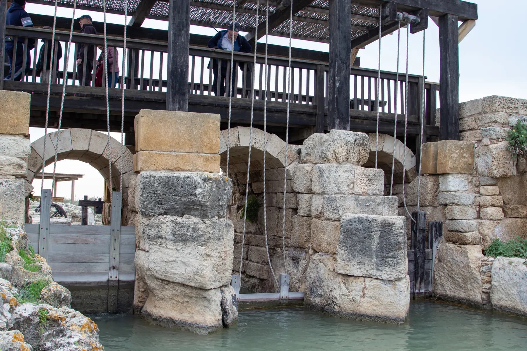
A stone wall 194 metres long, thrown across the gap the stream cut through the kurkar ridge, raised the water by three metres and turned the Kebara valley into a lake of about 6,000 dunams, which is the only reason Caesarea's low aqueduct could run downhill.
Beach
Caesarea Aqueduct and Aqueduct Beach
The arcade behind the sand north of the harbour is two Roman aqueducts built hard against each other, and in February 2026 three bodies signed a ₪39 million agreement to stabilise all 85 of its arches.
israel zeller ישראל זלר / CC BY 2.5 · Wikimedia Commons
Archaeological site
Crusader City and Ramparts
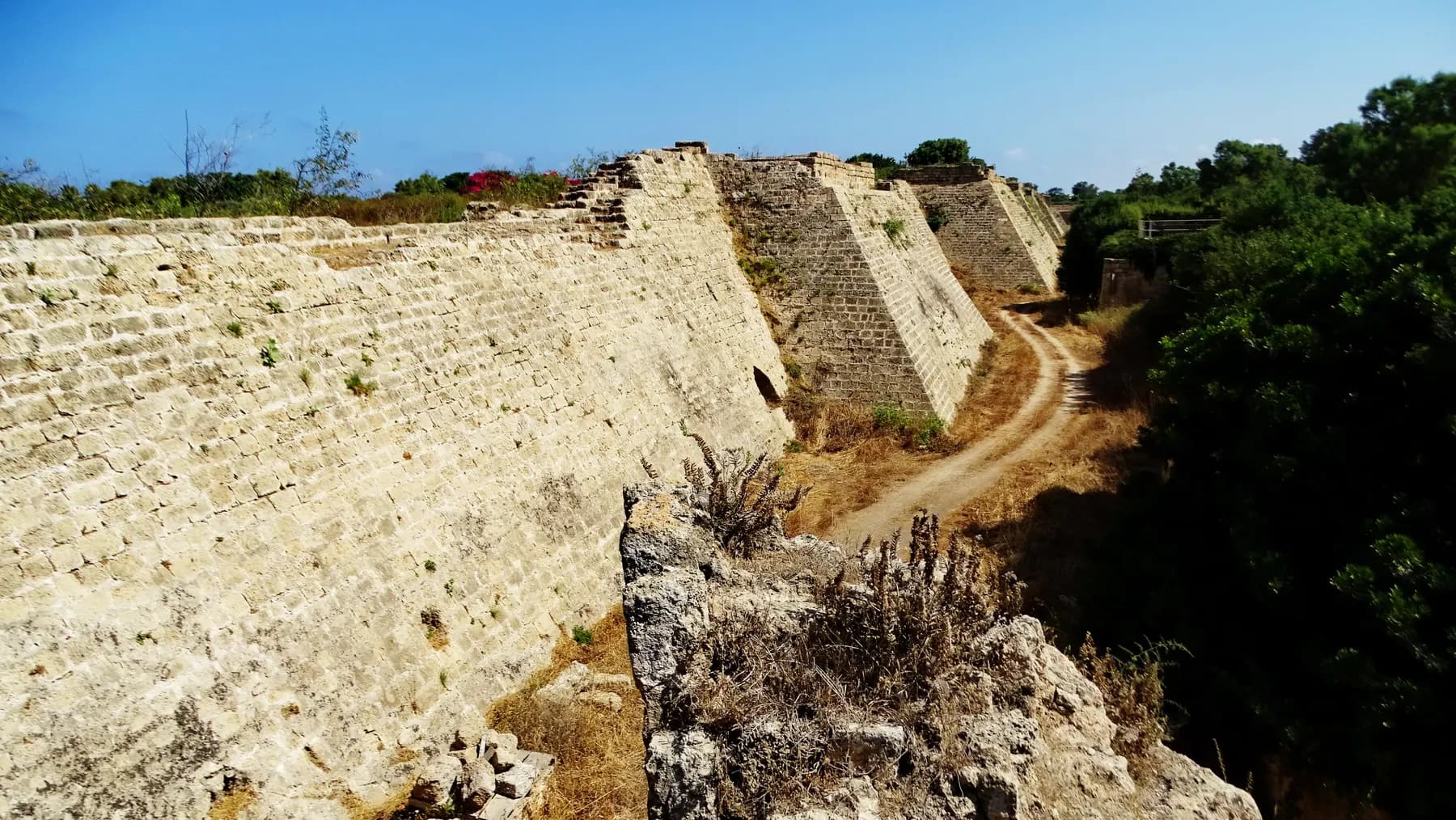
Louis IX of France walled a town of about 120 dunams here in 1251, a fraction of the Roman city, and cut a dry moat round it that the park's operator still measures at 8 to 10 metres deep.
Sources and further reading
Every link below was opened and checked when this page was written. Official statements are marked as such: they are the subject's own account, not an independent one.
- OfficialJisr az-Zarqa Local Counciljisr-az-zarqa.muni.ilJisr az-Zarqa, English pages
Local council status in 1963, the town on a sandstone ridge 25 m above sea level, the claim to be the only Arab town on the Mediterranean coastal plain, the fishermen's village founded in 1922 and described as the only one still active on the Israeli coast with about thirty boat-owning families, the free beach with lifeguard services and shaded areas and parking, the 1,200 m² mosque of 2001, the 442 m aqueduct tunnel with 15 shafts, the bridge built for Kaiser Wilhelm II's visit of 1898, and Tel Tanninim
- OfficialJisr az-Zarqa Local Counciljisr-az-zarqa.muni.ilNatural and historical resources
The Umar ibn al-Khattab mosque, built in 1968 as one storey and rebuilt in 2001 with the An-Nahda society over three floors, and the Roman tunnel of 442 m with 15 shafts on the Beit Hananya to Caesarea line, stated to be closed to the public pending a plan for visitor access
- OfficialJisr az-Zarqa Local Counciljisr-az-zarqa.muni.ilHospitality and restaurants
The council's own list of visitor businesses: Juha's Guesthouse, The Blue Bridge Experience (founded 2016), the Al-Zarqa Gallery run by women of the town, and Zarka Tours, with the phone numbers and email addresses that are the only way to book any of them
- OfficialJisr az-Zarqa Local Counciljisr-az-zarqa.muni.ilThe Israel National Trail through the town
Young people of the town, with the Basmala association, maintaining their section of the national trail and hosting walking groups under a Nature and Parks Authority programme, with waymarks and a QR code carrying local information
- ReportingThe Times of Israeltimesofisrael.comOverlooked Arab Israeli beach town opens its doors to tourists
June 2015 report on Juha's Guesthouse and its founders Neta Hanien and Ahmad Juha, the earthen wall separating the town from Caesarea 200 metres away, Juha's description of the village as an island, the population then given as 13,000 with half under nineteen, and the fishing boats and fish restaurants
- ReportingThe Times of Israeltimesofisrael.comIn poor Arab villages like Jisr a-Zarka, poverty and alienation keep people from the polls
The town wedged between the coastal highway and the sea north of Caesarea, the reported share of families below the poverty line, income at about half the national figure, and the low share of residents with academic education
- DataCentral Bureau of Statisticscbs.gov.ilLocal Authorities in Israel 2023: profile of Jisr az-Zarqa (publication 1987)
Population 15,709 at end 2023, municipal symbol 541, local council since 1963 with 13 members, Haifa district, 100 percent Muslim, area 1.65 km² of which 0.83 km² housing, density 9,522 per km² and 18,452 per km² of built residential land, socio-economic cluster 2 of 10 with rank 18 of 255 for 2021, periphery cluster 5, and the 2022 wage data (mean ₪7,642, 39.2 percent below minimum wage, 68.9 percent below median)
- ReferenceWikipediaen.wikipedia.orgJisr az-Zarqa
The Ghawarina clans and their origins, the Palestine Exploration Fund survey of 1882 on the dam and the marsh encampments, the 1887 list of about 335 inhabitants, the mandate censuses of 1922, 1931 and 1945 and the 3,428 dunams, the intervention by Zikhron Ya'akov and Binyamina in 1948, the November 2002 embankment along the 160 m corridor and the reasons given for it, pollution and overfishing, the coastal highway built without access, and the excavated Roman and Byzantine remains
- ReferenceWikipediahe.wikipedia.orgג'סר א-זרקא (Jisr az-Zarqa, Hebrew)
The resettlement of the marsh dwellers onto the kurkar ridge in 1926 on land bought in exchange, the description of the town as the only Arab locality founded by Zionist institutions, the bridge over Highway 2 in the north and the underpass in the centre, the small fishing harbour near the stream mouth with few residents now living from fishing, employment in teaching, domestic work and regional industry, the guesthouse opening in 2013, the embankment built by Caesarea residents at the end of 2002, and the restoration of the bridge in 2020
- ReferenceWikipediahe.wikipedia.orgביצות כברה (The Kabara marshes)
The marshes as the second largest in the country after the Huleh at about 6 km², malaria and anopheles, the Jewish Colonization Association purchase in 1922 with Rothschild funds and the transfer to PICA in 1924, the engineers Leon Krone and Dov Koblanov, the Ghawarina living from fishing, buffalo and reeds, and PICA buying replacement land and establishing Jisr az-Zarqa on the kurkar ridge in 1926
Jisr az-Zarqa: common questions
What is Jisr az-Zarqa?+
It is an Arab town of about 15,700 people on the coast immediately north of Caesarea, and its local council describes it as the only Arab town on Israel's Mediterranean coastal plain. The present town was laid out on a sandstone ridge in 1926, for Ghawarina marsh Arabs displaced when the Kabara marshes were drained. Its name is Arabic for the bridge over the blue, after the crossing of Nahal Taninim.
Is there really a working fishing village?+
Yes, though the scale is small and the sources differ on how small. The local council dates the fishermen's village to 1922, calls it the only remaining active fishing village on the Israeli coast, and says about thirty families own boats. The Hebrew account of the town agrees there is a small harbour with boats at the stream mouth but says few residents now make a living from fishing, and the English account cites pollution and overfishing as the pressures on it.
Does it cost anything to visit?+
No. There is no ticket, no gate and no visitor centre, and the council states that entrance to the beach is free. Money is spent here on food, on a guesthouse room, on a workshop at the gallery or on a guided walk, all of which are priced by the individual operators rather than published by the council.
Can you swim at Jisr az-Zarqa?+
Yes. The council lists a public bathing beach with lifeguard services and a lifeguard hut, shaded areas and parking, at no charge. It publishes no bathing season or lifeguard hours, so anyone planning to swim outside high summer should ring the council first. It is a working shore rather than a groomed resort beach.
How do I get there from Caesarea National Park?+
By road, out to Highway 2 and back in, not along the coast. The two places are neighbours, separated by a corridor of open ground about 160 metres wide, but that corridor was blocked by an earth embankment in 2002 and there is no walking route through it. From the highway, the town is entered by a bridge over the road at its northern end or an underpass in the middle.
Why is there a bank of earth between Jisr az-Zarqa and Caesarea?+
The Caesarea Development Corporation built it in November 2002 along the 160-metre corridor separating the two places. The reasons given were noise from the muezzin in the town's mosques, celebratory gunfire and property crime in the surrounding communities. Residents of Jisr az-Zarqa say the embankment, together with the national park to the south, the highway to the east and the sea to the west, is what prevents the town from expanding.
Can you stay overnight?+
Yes. Juha's Guesthouse, set up by Neta Hanien and Ahmad Juha and dated by the Hebrew account to 2013, offers rooms along with cookery workshops and guided tours, and The Blue Bridge Experience, founded in 2016, arranges hosting, meals and workshops with local families. Both are booked directly by phone or email through the contacts on the council's hospitality page.
Is it safe, and how should visitors behave?+
It is an ordinary residential town and visitors are actively wanted here, which is the point of the guesthouse, the gallery and the guiding businesses. The usual courtesies apply and matter more than at a ticketed site: ask before photographing people or houses, dress modestly, and expect the town to be quiet during Friday midday prayers. The statistics bureau records the population as entirely Muslim.
Is it wheelchair accessible?+
Only partly. The town sits on a ridge 25 metres above the sea and its streets are steep, narrow and often without pavements, so the residential centre is difficult. The beach is the workable part, with parking, shade and a lifeguard hut, although the final approach to the water is over sand, and the fishing harbour is reached over sand and rock.
Is it worth adding to a day at Caesarea?+
It depends on what the day is for. If the point is Roman and Crusader archaeology, this adds nothing: there is no excavated site to walk round and the one Roman feature under the town, the aqueduct tunnel, is closed. If the point is the coast as people actually live on it, an hour at the harbour and a fish lunch is the sharpest contrast available a short drive from the park gate.