Archaeological site · Caesarea
Crusader City and Ramparts
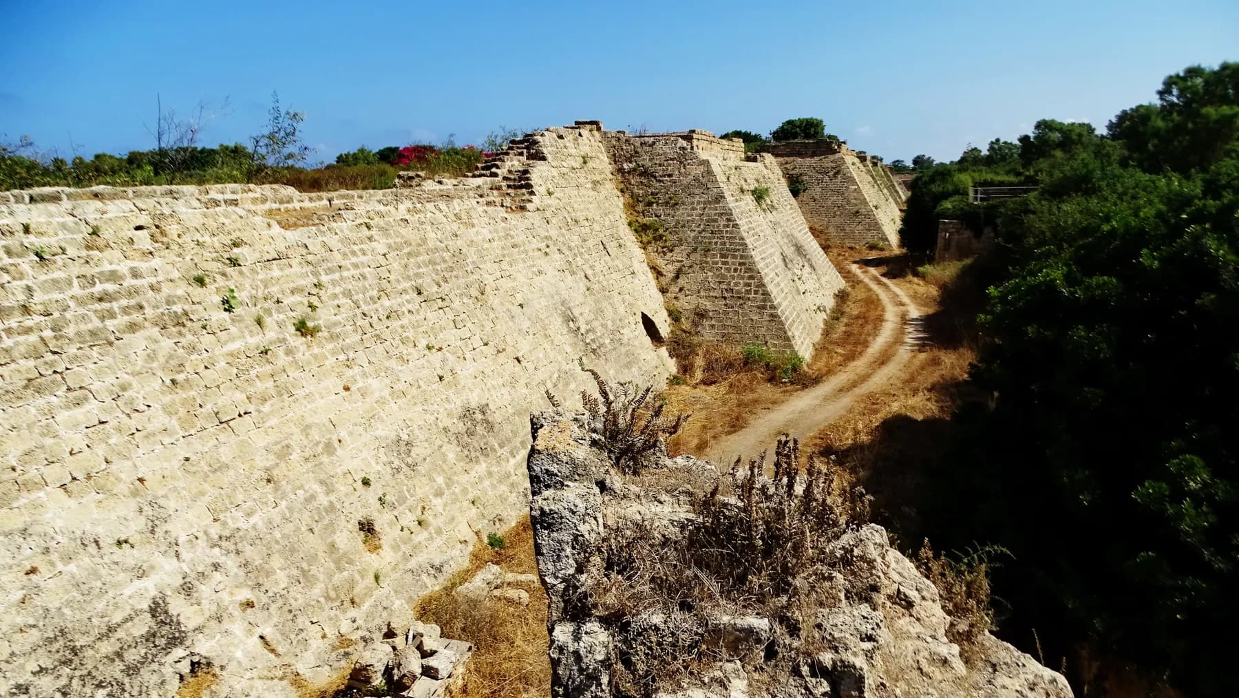
Louis IX of France walled a town of about 120 dunams here in 1251, a fraction of the Roman city, and cut a dry moat round it that the park's operator still measures at 8 to 10 metres deep.
israel zeller ישראל זלר / CC BY 2.5 · Wikimedia Commons
Walled area
about 120 dunams
the town Louis IX fortified in 1251
Moat
8 to 10 m deep
and about 15 m wide, per the foreign ministry's account
Rampart promenade
about 1,500 m
from the southern gate round to the north
Towers
15 or 16
the operator's own two pages give different counts
In short
- How long to give it
- about 90 minutes for the gate, the rampart walk and the moat, longer if the harbour is included
- Summer, Sunday to Thursday and Saturday
- 08:00–17:00
- Adult
- ₪46
העיר הצלבנית וחומותיה
The Crusader city is the walled medieval town at the northern end of Caesarea National Park, and for most visitors it is the first thing they touch, because the park's northern entrance runs through its gate. A bridge crosses a dry moat, the path turns sharply inside a vaulted gatehouse, and the visitor comes out on a street of ruins with the harbour ahead. Everything else at Caesarea is Roman or Byzantine and lies outside these walls. This is the one part of the site built by Europeans, in the middle of the thirteenth century, and the one part designed to be difficult to enter.
It is also the smallest Caesarea there has ever been. The Caesarea Development Corporation puts the area enclosed at about 120 dunams; the account published by the Israel Ministry of Foreign Affairs gives roughly 40 acres, which is about 160 dunams. Either way the Frankish town sat inside a corner of a Roman city that had run for kilometres along this shore, with the Roman theatre and the racecourse left outside as quarries and open ground. The Crusader town did not even inherit the aqueducts: it made do with an open canal.
The fortifications are the reason to come. They are among the most complete thirteenth-century defences standing in Israel, and because they were built in one campaign rather than accumulated over centuries, they read as a single design: moat, sloping glacis, curtain wall, towers with arrow slits, three gates that force a turn, and a hidden tunnel down into the ditch. Much of what a visitor walks on has been reset and consolidated, twice, and the park says so.
Arrival
A gate built so that nobody could walk straight through it
The Israel Nature and Parks Authority describes the north-eastern entrance to Caesarea as passing through a restored monumental structure it calls the Crusader Gate. The Caesarea Development Corporation, describing what appears to be the same building, calls it the eastern gate. The naming is inconsistent between the two operators of the site; the structure is the one every visitor entering from the northern car park walks through.
The design is a bent entrance. The parks authority notes that the gates were built to prevent a direct run at the target, using turns, and to expose anyone who got inside to fire from the town. The corporation makes the same point in physical terms: the gatehouse is shaped so that it blocked an attacker's field of vision and made a charging horse difficult to keep at speed. The foreign ministry's account calls it indirect access and adds the fittings: a square gatehouse with a cross-vaulted ceiling carried on consoles cut with floral motifs, doors barred from the inside with timber and protected on the outside by an iron grill that dropped through a slot in the ceiling.
In front of the gate was a bridge. The two published descriptions differ on what it was made of. The foreign ministry describes a bridge carried on arches, springing from piers set at the bottom of the moat. The Caesarea Development Corporation describes a wooden bridge, half of it fixed and half of it able to be raised, which could be burned if the town was threatened. Both are plausible for a Crusader gate: a masonry approach ending in a short timber span that could be lifted or destroyed. No source consulted here settles it.
One detail is easy to miss and worth stopping for. Stand inside the gate and look up: the parks authority points out a stone cut in the shape of a cross at the centre of the arch.
History
Four conquests and one building campaign
Baldwin I took Caesarea in 1101, in the wake of the First Crusade. He demanded surrender, the town's emir refused, and the siege began on 2 May with trebuchets; the defences broke after fifteen days, and the Crusaders killed part of the male population, enslaved women and children and looted the place. Caesarea became a lordship of the Kingdom of Jerusalem with its own Latin archbishop, and the Franks held it from 1101 to 1187 and again from 1191, after Richard I retook it during the Third Crusade. Saladin had held it in the interval.
The walls a visitor sees are later than all of that. In 1251, during the Seventh Crusade, Louis IX of France refortified the town. He was in the Levant from 1250 to 1254, and Caesarea was one of four places, with Acre, Haifa and Jaffa, whose defences he paid to rebuild. The Israel Ministry of Foreign Affairs dates the work to 1251 and 1252 and describes a wall about 4 metres thick and some 1.6 kilometres long, with a glacis, towers and a moat.
The Caesarea Development Corporation's own pages do not agree with each other on the date. Its page on the Crusader period gives 1251, which matches every other source consulted; its page on the recent restoration project gives 1265, which is the year the town fell. Treat 1251 as the date of the walls.
The end came fourteen years after they went up. In 1265 the Mamluk sultan Baibars attacked. Wikipedia's account, following the standard secondary literature, has him ordering his troops to scale the walls in several places at once; the foreign ministry's version has the defenders giving up hope after a short siege and evacuating. What is not in dispute is what happened next. Baibars had the fortifications razed, as the Mamluks did to the other Crusader ports on this coast, so that no returning Frankish force could use them. Nobody lived inside these walls again until 1880, when Bosniak refugees built a village here out of the ruins.
Fortification
Moat, glacis and the tunnel under the wall
The moat is dry, and it is the part of the system that survives best because it was cut rather than built. The Caesarea Development Corporation puts it at 8 to 10 metres deep; the foreign ministry's account gives 10 metres deep and 15 metres wide. Above it runs the glacis, a smooth masonry slope falling from the foot of the wall to the ditch, which the corporation translates as the great slope. An attacker who reached the wall had first to cross open ground, then drop into the ditch, then climb a slick angled face under fire.
The curtain wall carried towers with embrasures, the narrow openings cut for archery and widening inwards so that a bowman could swing his aim. Counting them is where the published sources part company: the corporation's page on the Crusader period says fifteen towers and three gates, while its page on the 2015 to 2019 restoration says sixteen. Neither figure is sourced on the page that prints it.
The feature most visitors do not expect is the postern. A concealed tunnel runs from inside the town out into the moat, and the corporation says it was used to bring food and ammunition to the defenders without opening a gate. It has been made passable: visitors can descend through it to the floor of the ditch. It is steps, in the dark, and it is not a route for anyone unsteady.
The rampart walk runs along the top of all of this. The corporation gives the promenade as about 1,500 metres, beginning at the southern gate of the Crusader city, with towers to climb and observation points looking south over what it calls the Roman amusement district: the theatre, the hippodrome, the bathhouse and the promontory palace.
- Moat: 8 to 10 m deep by the corporation's figure, 10 m deep and 15 m wide by the ministry's
- Wall: about 4 m thick and some 1.6 km long, per the ministry's account
- Towers: 15 on one operator page, 16 on another
- Three gates, all of the bent-entrance type
- A glacis running from the wall foot down into the ditch
- A postern tunnel from the town out into the moat, now walkable
Inside
A market street, a cathedral on Herod's podium, and the harbour
What is inside the walls is thinner than the walls themselves, because Baibars was thorough and because the Bosniak village of 1880 was built on top of whatever was left. The clearest surviving quarter is the Crusader market, where excavation exposed shops at ground level with living rooms above them, some floored in coloured mosaic and some in marble slabs.
The cathedral stood on the artificial podium Herod had raised for his temple to Augustus, which by the thirteenth century was simply the highest platform in town. The foreign ministry's account describes a twelfth-century building with its eastern end added in the middle of the thirteenth, a nave and two aisles ending in three apses, mosaic floors, and vaulting carried on rectangular piers. What stands today is a fragment: the main apse and one side apse, open to the sky above the harbour.
The harbour compound sits inside the same circuit, which is why the Crusader city and Herod's harbour are hard to separate on the ground. The medieval town clustered round the silted basin that the Romans had abandoned, and the vaults that now hold the harbour visitor centre were medieval cellars long before they were an exhibition. A ruined citadel stands out on the mole, surrounded by sea.
Excavation has not finished. The 2025 season of the current dig, listed by the Biblical Archaeology Society, worked in the northern city on a nineteenth-century Bosnian house that sits directly on top of the main north-south Crusader road, which is a fair summary of how the layers here are stacked.
Restoration
Which stones are Crusader, and which were put back
This is the question the site's own signage answers less directly than it might, so it is worth setting out. The gatehouse is a reconstruction. The Caesarea Development Corporation says the eastern gate was restored during the 1960s using its original stones, meaning the fallen material was identified and reset rather than replaced with new masonry. The parks authority's Hebrew description is blunter still, calling the structure at the north-eastern entrance a restored monumental building.
The second campaign is recent and much larger. Between 2015 and 2019 the corporation, working with the Israel Antiquities Authority and the parks authority, rebuilt the visitor route through the fortifications. Its own account lists what was done: missing stones completed, cracks and cavities filled, safety hazards removed from inside the walls, stairs to some of the watchtowers restored, shading installed, and the Crusader bridge that led to the north gate rebuilt so that walkers can cross and continue north towards the aqueduct beach. The postern into the moat was opened as a public route in the same programme.
So the honest reading is layered. The line of the moat, the cut of the glacis and the footprint of the wall are thirteenth-century work and largely undisturbed. The wall face a visitor touches is Crusader stone with modern completions between it. The stairs, the railings, the shading and the bridge are recent. The cross-vaults of the gate are genuine medieval construction, reassembled sixty years ago.
None of that makes the place a replica. It does mean that the smooth, continuous rampart walk is a twenty-first century product laid over a thirteenth-century plan, and a visitor who wants to see the difference should look down into the moat, where nothing needed rebuilding.
What to look for
Things not to walk past at Crusader City and Ramparts
The details that repay knowing about before you are standing in front of them.
The cross in the keystone
Stand under the arch of the Crusader gate and look up. The parks authority points out a stone cut in the shape of a cross at the centre of the vault.
The bend inside the gatehouse
The entrance turns rather than running straight. It was built that way to cut an attacker's sightline and to break the momentum of a charging horse.
The postern down to the moat
A concealed tunnel from the town into the ditch, used to resupply the defence without opening a gate. It is now a public route, by steps.
The glacis
The sloped masonry face running from the foot of the wall into the moat, translated on the operator's own signage as the great slope. It is the clearest piece of unrestored engineering on the site.
The cathedral apses
The main apse and a side apse of the Crusader cathedral stand on the podium Herod built for his temple to Augustus, looking down on the harbour.
The view south from the towers
From the rampart the whole Roman entertainment quarter lines up: theatre, hippodrome, bathhouse and the promontory palace on its spit of rock.
The long view
Crusader City and Ramparts, in order
1101
Baldwin I besieges Caesarea from 2 May with trebuchets and takes it after fifteen days; the town becomes a lordship of the Kingdom of Jerusalem.
1187
Saladin recaptures the city.
1191
Richard I retakes it during the Third Crusade.
1251–52
Louis IX of France refortifies the town: wall, glacis, towers, three bent gates and a moat around roughly 120 dunams.
1265
Baibars takes the town and has the fortifications deliberately razed so that no Crusader force can reuse them.
1880
Bosniak refugees are settled on the site and build a village inside and over the Crusader ruins.
1960s
The gatehouse is restored using its own fallen stones.
2015–2019
The Caesarea Project consolidates the fortifications, restores tower stairs, rebuilds the bridge to the north gate and opens the postern into the moat.
2025
Excavation continues in the northern city, on a nineteenth-century Bosnian house standing on the main Crusader street.
Practical
Visiting Crusader City and Ramparts
Where
Caesarea National Park, northern entrance, beside Caesarea harbour
What ticket you need
The Crusader city is not separately ticketed: it is the northern end of Caesarea National Park, and the ₪46 adult ticket covers it. The parks authority's price list also carries a separate line for entry to Caesarea harbour at ₪18, which is a smaller ticket for the harbour compound rather than the full park. If the walls and the Roman theatre are both on the list, buy the full park ticket.
Opening hours
- Summer, Sunday to Thursday and Saturday
- 08:00–17:00source
- Summer, Friday and holiday eves
- 08:00–16:00source
- Winter, Sunday to Thursday and Saturday
- 08:00–16:00source
- Winter, Friday and holiday eves
- 08:00–15:00source
- Yom Kippur eve, and the eves of Rosh Hashanah and Passover
- 08:00–13:00source
- Last entry
- One hour before the stated closing timesource
Admission
Access
Partly, and the split matters. The parks authority lists the harbour compound and the ancient city among its step-free areas, with accessible parking at both ends of the park, concrete or timber paths from the entrances to the points of interest, handrails on steps, shaded seating and accessible lavatories. The rampart walk is not in that list. Climbing the towers is stairs, and the postern down into the moat is a flight of steps in a dark tunnel, so neither is possible in a wheelchair. A visitor who cannot manage steps can still pass through the gatehouse, follow the seafront promenade and see the walls from below.
On site
- Toilets at the park entrance
- Accessible parking at both entrances
- Cafes and restaurants on the harbour
- Shops and galleries
- Shaded seating on parts of the rampart
- Signage in Hebrew, English and Arabic
Booking
Groups of more than ten should book through the parks authority. On Saturdays and holidays the authority recommends arriving early, because entry is on the basis of available space, and anyone who booked ahead should have the confirmation to hand at the gate.
Hours and prices are given as the operator publishes them and change without much notice, particularly around Shabbat and the festivals. Check the operator's own page before you travel for this.
Official page at en.parks.org.il →What people wish they had known
- Come in through the northern gate if the Crusader city is the point of the visit. The park has two entrances and the southern one puts a walk of well over a kilometre between the car and the walls; the harbour operator's own advice is to arrive from the north, through the Crusader gate.
- Do not treat the ₪18 harbour line on the price list as a cheap park ticket. It admits to the harbour compound, not to the theatre and the hippodrome at the far end, and the difference has to be settled if the plan changes mid-visit.
- Walk the rampart in the first or last hour of the day. There is shading at points along the promenade and nowhere near enough of it in the middle of the afternoon, and the stone reflects heat back up.
- Go down the postern. Most visitors stay on top of the wall and never find the tunnel into the moat, which is where the scale of the defence actually registers. It is steps, so leave the pushchair.
- Check the closing time before setting out, not on arrival. Last entry is a full hour before the gates shut, and in winter that means being inside by 15:00 on a weekday and by 14:00 on a Friday.
- Expect the medieval and the modern to be interleaved. The stairs, railings and the bridge over the moat are recent work; the ditch and the glacis are not.
The figures
Crusader City and Ramparts by the numbers
Each figure carries the year it belongs to and links the source it came from.
| Measure | Figure | As of | Source |
|---|---|---|---|
| Area enclosed by the Crusader wall | about 120 dunams | 2026 | caesarea.com |
| Wall thickness and length | about 4 m thick, some 1.6 km long, around roughly 40 acres | 2026 | jewishvirtuallibrary.org |
| Moat, as the ministry gives it | 10 m deep and 15 m wide | 2026 | jewishvirtuallibrary.org |
| Moat, as the park's developer gives it | 8 to 10 m deep | 2026 | caesarea.com |
| Towers on the circuit | 15 on one operator page, 16 on another | 2026 | caesarea.com |
| Rampart promenade | about 1,500 m, from the southern gate | 2026 | caesarea.com |
| Adult admission to the national park | ₪46 (child ₪27, Israeli senior ₪23) | 2026 | en.parks.org.il |
| Harbour-only entry line on the price list | ₪18 | 2026 | parks.org.il |
While you are here
The rest of Caesarea
Everything else in this destination with a page of its own.
זאב שטיין / CC BY 2.5 · Wikimedia Commons
Archaeological site
Herod's Harbour (Sebastos)
The breakwaters that made Caesarea possible are still there, five to seven metres down, and the harbour began settling into the seabed almost as soon as it was finished.
Museum
Caesarea Harbour Visitors' Centre
Four of the fourteen Herodian vaults that carried the temple platform above the harbour were dug out, stabilised and opened to the public in June 2019, after about five years of work.
Beach
Caesarea Aqueduct and Aqueduct Beach
The arcade behind the sand north of the harbour is two Roman aqueducts built hard against each other, and in February 2026 three bodies signed a ₪39 million agreement to stabilise all 85 of its arches.
Sources and further reading
Every link below was opened and checked when this page was written. Official statements are marked as such: they are the subject's own account, not an independent one.
- OfficialIsrael Nature and Parks Authorityen.parks.org.ilCaesarea National Park
Summer and winter opening hours, last entry one hour before closing, the entrance fee table (₪46, ₪27, ₪39, ₪23), the accessibility list and the directions
- OfficialIsrael Nature and Parks Authorityparks.org.ilגן לאומי קיסריה (Caesarea National Park, Hebrew)
The Crusader Gate as the restored north-eastern entrance, the bent gates and glacis, the cross-shaped stone in the arch, the full price list including the ₪18 harbour line and the ₪10 pupil rate, holiday-eve closing at 13:00, and accessible parking at both ends
- OfficialCaesarea Development Corporationcaesarea.comThe Crusader Period
Louis IX's fortifications of 1251, about 120 dunams, fifteen towers with embrasures, three gates, the great slope, the 1,500 m wall promenade, the half-arch gate, the part-raising wooden bridge and the 1960s restoration using original stones
- OfficialCaesarea Development Corporationcaesarea.com2015-2019 The Caesarea Project
The moat at 8 to 10 m deep, the postern used to resupply the defence, sixteen guard towers, the restored bridge to the north gate, the Crusader market with shops below and dwellings above, and the conservation works and shading
- OfficialCaesarea Development Corporationcaesarea.comCaesarea Harbor Visitors' Center: FAQ
The operator's own recommendation to arrive from the northern entrance through the Crusaders' Gate, and the two main park entrances north and south
- ReportingBiblical Archaeology Societybiblicalarchaeology.orgCaesarea Maritima: excavation programme
Fifty years of consortium excavation covering the Crusader church and city walls, and the 2025 season in Area NC on a nineteenth-century Bosnian house sitting on the main north-south Crusader road
- ReferenceJewish Virtual Library, reproducing the Israel Ministry of Foreign Affairs accountjewishvirtuallibrary.orgCaesarea
Louis IX's work dated 1251-52, a wall about 4 m thick and 1.6 km long around some 40 acres, a moat 10 m deep and 15 m wide, the indirect-access main gate, the arched bridge on piers in the moat, the cross-vaulted gatehouse with floral consoles and an iron grill, the cathedral on Herod's podium, the 1265 evacuation and the 2018 coin and earring hoard
- ReferenceWikipediaen.wikipedia.orgCaesarea Maritima
The 1101 siege from 2 May with trebuchets and its fifteen days, the lordship and Latin archbishopric, Saladin in 1187 and the Crusader return in 1191, Louis IX's high walls and deep moat in 1251, Baibars scaling the walls in 1265 and razing the town, Benjamin of Tudela's count, the 85 percent contraction of the city, the surviving citadel and cathedral remains, and the Crusader town's open water canal
- ReferenceWikipediaen.wikipedia.orgSeventh Crusade
Louis IX repairing the fortifications of Acre, Haifa, Caesarea and Jaffa during his stay in the Levant
- ReferenceWikipediaen.wikipedia.orgLouis IX of France
That Louis concentrated his rebuilding of Crusader defences on Acre, Caesarea and Jaffa, and funded the reconstruction himself
Crusader City and Ramparts: common questions
What is the Crusader city at Caesarea?+
It is the walled medieval town at the northern end of Caesarea National Park, fortified by Louis IX of France in 1251 and 1252 and destroyed by the Mamluks in 1265. It occupied a small corner of the far larger Roman city, enclosing about 120 dunams by the Caesarea Development Corporation's figure. Its moat, glacis, curtain wall, towers and gates are the most complete thirteenth-century defences on this coast.
Do I need a separate ticket for the Crusader city?+
No. It is part of Caesarea National Park, and the Israel Nature and Parks Authority's park ticket covers it: ₪46 for an adult, ₪27 for a child, ₪23 for an Israeli senior citizen. The authority's price list also shows a ₪18 line for entry to Caesarea harbour, which is a smaller ticket covering the harbour compound rather than the whole park.
Can you walk on the Crusader walls?+
Yes. The rampart promenade runs about 1,500 metres from the southern gate of the Crusader city, with towers to climb and observation points over the Roman theatre, hippodrome, bathhouse and promontory palace. The route was rebuilt as part of the 2015 to 2019 works, with tower stairs restored and shading added at points.
Can you go down into the moat?+
Yes, through the postern, a concealed tunnel that ran from inside the town out into the ditch. The Caesarea Development Corporation says the Crusaders used it to bring in food and ammunition without opening a gate, and it has been opened as a visitor route. It is a flight of steps in an enclosed passage, so it is not for anyone unsteady on stairs.
Is any of it original, or has it all been rebuilt?+
The plan is original and much of the fabric is not. The cut of the moat, the glacis and the line of the wall are thirteenth-century work; the gatehouse was reassembled in the 1960s from its own fallen stones; and between 2015 and 2019 missing stones were completed, cracks filled, tower stairs restored and the bridge to the north gate rebuilt. The moat is the part that needed least intervention and shows it.
How long does it take?+
About 90 minutes covers the gate, the rampart walk and a descent into the moat at an unhurried pace. Adding the harbour, the visitor centre in Herod's vaults and the walk south to the Roman theatre turns it into a half day. Very little of the route is shaded, which shortens most people's tolerance in summer.
Is it wheelchair accessible?+
Partly. The parks authority lists the harbour compound and the ancient city as accessible, with accessible parking at both entrances, concrete or timber paths, handrails and accessible lavatories, so the gatehouse and the seafront promenade can be done. The rampart walk, the tower stairs and the postern into the moat cannot: they are steps throughout.
Why is the Crusader town so much smaller than the Roman city?+
Because there were far fewer people to defend and far less money to defend them with. Roman and Byzantine Caesarea spread over several square kilometres; by the twelfth century Benjamin of Tudela counted only a couple of hundred Jewish and Samaritan households, and the enclosed area of the city had shrunk by more than 85 percent between the Byzantine and Fatimid periods. Louis IX walled what could be held, and the Roman monuments were left outside.
Is there shade on the rampart walk?+
Some, and not much. Shading was installed at points during the second phase of the restoration project, and there is shaded seating in the harbour compound below, but the wall top itself is open stone facing the sun and the sea. A hat and water are the difference between an hour on the walls and twenty minutes.
Is it worth it if I have already seen the Roman theatre?+
Yes, because it answers a different question. The theatre and the racecourse show a Roman provincial capital at its height; the walls show what was left of the same place a thousand years later, when a French king paid to fortify a town a fraction of its size against a besieger who arrived fourteen years afterwards and levelled it. The two are a fifteen-minute walk apart inside one ticket.