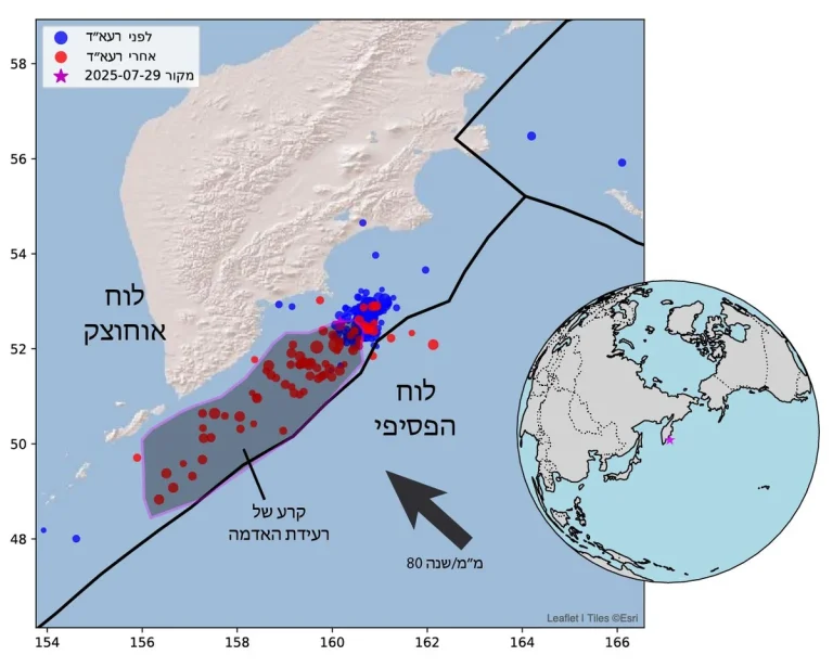


The quake was caused by the Pacific Plate moving northwestward beneath the Okhotsk Plate at a rate of 80 mm per year. For comparison, the movement along the Dead Sea Fault (Syrian-African Rift) is about 5 mm per year.
In fact, an earthquake of this magnitude is not a single-point event – it involves the displacement of a massive area, approximately 500 km by 150 km (outlined in pink on the map), roughly the size of the State of Israel! A huge slab of Earth’s crust shifted about 6 meters along a vast subduction zone.
The earthquake occurred following a seismic swarm that began on July 19, which included over 50 quakes above magnitude 5, including one at 7.4 and three others at 6.6. Since the mainshock, at least 24 aftershocks above magnitude 5.0 have been recorded, including one at 6.9.
Massive earthquakes have occurred in this region before: a 9.0 quake struck in 1952, and an 8.4 in 1923. Preliminary analyses suggest that the 2025 earthquake may have “closed the gap” left between the rupture zones of the previous events.
The earthquake also triggered tsunami waves, with waves several meters high recorded at various monitoring stations across the Pacific Ocean. Tsunami warnings were issued for the coasts of Kamchatka, the Kuril Islands, and even parts of Hawaii and Alaska. Fortunately, no widespread damage or casualties were reported from the tsunami, but the event highlighted the deadly potential of such megathrust earthquakes in subduction zones.
Writing and figure: Nadav Wetzler
The Kamchatka Earthquake – One of the Strongest Ever Recorded