


By TPS-IL • December 18, 2025
Jerusalem, 18 December, 2025 (TPS-IL) — A new computational tool developed at the University of Haifa is changing how archaeologists document and analyze ancient ruins, using drone imagery and machine learning to reveal architectural patterns that cannot be identified from ground level.
“Sites that appear on the surface as scattered stones suddenly become coherent, organized spaces, and it saves a lot of research time,” Dr. Yitzchak Jaffe of the University of Haifa’s School of Archaeology and Maritime Cultures, one of the study’s authors, told The Press Service of Israel. “And this system is unique in its implementation in the field of archaeology.”
The tool combines high-resolution drone imagery with machine learning to identify individual building stones and wall segments across archaeological sites. Within minutes, the system can map hundreds of thousands of stones and translate what looks like visual chaos into a detailed, measurable site plan. It was recently evaluated in the peer-reviewed Journal of Archaeological Science.
Ancient settlement sites often frustrate both researchers and visitors. From the ground, collapsed walls and eroded structures resemble random piles of stone, and even extended fieldwork can fail to clarify how a site was originally laid out. While drone photography offers a broader perspective, turning aerial images into usable archaeological data has until now required long and labor-intensive manual processing.
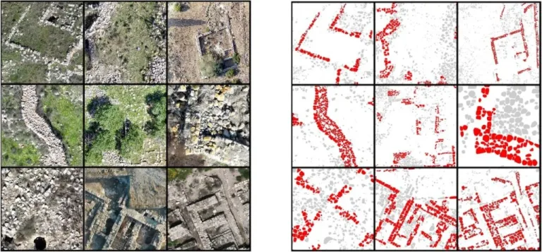
Aiming to bridge that gap, the Haifa University team worked with hundreds of drone images captured above archaeological ruins, stitching the photographs into precise spatial maps and elevation models. These maps were then divided into hundreds of small sections used to train two machine learning models. One model was taught to identify individual building stones, while the second detected wall segments.
Both models were trained using thousands of manually labeled examples. Once trained, the system cross-referenced stone and wall layers to generate a detailed site plan in which each stone is fixed to its exact location and associated with a specific wall segment. According to doctoral researcher Erel Uziel, a co-author of the study, the result is a level of spatial precision that was previously unattainable without extensive excavation.
The system was then tested at nine archaeological sites across Israel. In total, it identified roughly 350,000 building stones, about 20 percent of which were classified as part of wall structures. The researchers found that the tool performed accurately even at sites with dense vegetation, varied soil colors, or partial preservation—conditions that typically complicate archaeological documentation.
By integrating stone-level data with wall segmentation, the tool enables researchers to identify construction types, architectural styles, and spatial organization across entire settlements. This, the team says, opens new possibilities for analyzing how sites developed over time, how neighborhoods were planned, and how architectural choices shifted across periods.
The implications extend beyond documentation. With precise spatial data, archaeologists can identify areas of high research potential and plan excavations more strategically, reducing unnecessary digging and better preserving sensitive areas, the team said. The tool also allows scholars to ask new research questions that depend on accurate spatial relationships, such as changes in building density, reuse of materials, or variations in construction techniques within a single site.
Hai Ashkenazi, an archaeologist and manager of Geoinformatics at Israel’s Antiquities Authority, told TPS-IL that the tool might be “very helpful.”
“At first glance, this could be a development that would be very helpful for us at the Antiquities Authority, since it makes it possible to quickly draft site plans. At the moment, we are still testing it to see that it works with our files and across different types and colors of terrain,” he said.
Related Topics